| |
Introduction
Pinatubo volcano is one of the 21 active volcanoes in the Philippines
and lies at the boundaries of three of the administrative provinces
of Luzon (Fig. 20). It is part of a 220 km-long, NNW-trending, chain
of volcanoes that border the western side of Luzon. Pinatubo was
the highest of the composite volcanoes in the Zambales chain with
a pre-eruptive summit altitude of 1745 m. The Pinatubo massif is
comprised of Quaternary andesitic to dacitic ash fall and pyroclastic
flow deposits that originated from several vents near the volcano's
summit. Although volcanism in the Zambales chain began 7 million
years ago, Pinatubo has probably been active for only the last 1.1
million years. Its last know eruption was 460 ± 30 years ago and
involved eruption of voluminous pyroclastic flows and associated
lahars. Other eruptive periods with large pyroclastic flows were
2600-3000, 4400-5200, and 8000 years before present. As much as
6.7 km3 of materials were deposited on the eastern volcano
flanks in some of these past eruptions.
The semi-nomadic Aeta and Negrito tribes inhabited the slopes of
Pinatubo and grew coffee, rootcrops and bananas. Around 56 000 Aetas
were displaced by the 1991 eruption.
Precursory signs - scientific and management response
Pinatubo volcano was not one of the volcanoes monitored by the
Philippine Institute of Volcanology and Seismology (PHIVOLCS) and
hence its earliest pre-eruptive signs were not instrumentally detected.
A Sister working in a mission close to the volcano noticed steam
rising from Pinatubo's flanks on 2 April 1991, and travelled to
report this to PHIVOLCS on April 4. She reported rumblings, as well
as steam or ash emission from several vents. A quick response team
installed a temporary seismograph about 12 km WNW of the volcano
on April 5 as well as deformation gauges on the NW volcano flanks.
Continuing seismicity was recorded, prompting the installation of
three further seismometers around the volcano.
Figure 20.
 One week later a U.S. Geological Survey team joined the PHIVOLCS
group to assist with monitoring and preparation of hazard maps for
the volcano surrounds. Further telemetered seismometers and ground
deformation networks were installed and a central base established
at Clark Air Base (Fig. 20).
One week later a U.S. Geological Survey team joined the PHIVOLCS
group to assist with monitoring and preparation of hazard maps for
the volcano surrounds. Further telemetered seismometers and ground
deformation networks were installed and a central base established
at Clark Air Base (Fig. 20).
|
|
| |
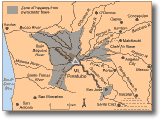
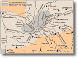
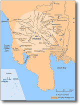
Hazard zonation maps for pyroclastic flows, lahars and ash falls were
completed by 23 May (Fig. 21a,b,c).
An alert system was devised to inform emergency agencies and the general
public of the state of the volcano. The alert system was based on
the daily number, type and total energy release of seismic events
at the volcano in addition to regular observations of its behaviour
(Table 9).
Table
9. Volcano alert signals used by PHIVOLCS for the 1991 eruption
of Pinatubo (PHIVOLCS, 1991).
|
Alert
level
|
Criteria
|
Interpretation
|
|
No
alert
|
Background,
quiet |
No eruption
in the foreseeable future |
|
1
|
Low level
seismic, fumarole or other unrest |
Magmatic,
tectonic or hydrothermal disturbance, no eruption imminent |
|
2
|
Moderate
level of seismic and other unrest with evidence for magma involvement |
(A) Probable
magmatic intrusion, could eventually lead to an eruption
(B) If trend shows further decline, volcano may soon go back
to level 1 |
|
3
|
Relatively
high unrest, including numerous earthquakes, fumaroles and gas
emission |
(A) If
trend is of increasing unrest, eruption is possible within 2
weeks
(B) If trend is one of decreasing unrest, volcano may soon go
to level 2 |
|
4
|
Intense
unrest, including harmonic tremor and or low frequency earthquakes |
Eruption
possible within 24 hours |
|
5
|
Eruption
in progress |
Eruption
in progress |
On April 5, alert level 1 was issued after the portable seismic
station recorded high seismic activity. On 6 June the alert level
was raised to 3 and, then to 4 on June 8 and the eruption (Level
5) began on June 9. The alerts were released by PHIVOLCS to the
government, national and local civil defence authorities, and the
media through daily volcano bulletins or advisories.
From the beginning of volcanic unrest until the final eruption,
a 10 km-radius high danger zone, centred on the volcano's summit
was delineated. People were advised to stay away from this area.
This zone was expanded to 20 km radius when alert level 5 was raised.
Due to the appearance of a fracture near the volcano's summit on
June 15, fears of a sector or flank collapse resulted in the danger
zone being expanded to a 40 km radius. This zone encompassed 22
towns and two cities. A few days after the major eruptive episodes
(14-16 June) the danger zone was reduced again to a 29 km radius,
and on September 4 it was reduced to 10 km radius.
Seismicity and other pre-eruption signals
The first sign of unrest from Pinatubo was a hydrothermal explosion
on April 2, with accompanying 500-800 steam and ash clouds. Nine
vents began emitting steam plumes on the NNW slope of the volcano.
The temporary seismometer, installed on April 5, recorded 223 high
frequency volcanic earthquakes in its first 24 hours of operation.
Until June 6, between 26-178 high frequency earthquakes were recorded
per day, due to the fracturing of rock by the pressure exerted by
rising magma.
Seismicity suddenly surged to 1500-2000 events per day on June 7.
Low frequency earthquakes, indicating shallow magma, were also recorded.
Around 10 hours before the first pyroclastic flows the most distinctive
low frequency earthquakes occurred. Also, the focus of the earthquakes
began to move from the NW to where the eruption was to break out.
The first harmonic tremors were recorded on June 9, and more occurred
from June 12 through to the major phase of the eruption on June
14-16.
Sulphur dioxide (SO2) content of gas emissions provided
another indicator of the volcano's state. A correlation spectrometer
(COSPEC) was used in over-flights of the volcano. On 13 May around
2000 tonnes per day of SO2 was being released, rising
to 5000 tonnes/day on 28 May. This increase indicated rise of magma
to the surface. On June 5 a sudden drop in SO2 emission
occurred (around 260 tonnes/day), due to magma having reached the
surface and plugging gas exit conduits.
The first ash emissions (each around 30 minutes long) began in the
morning of June 3, with short intervals between them until June
4. After a lull, a sudden surge of seismicity with an explosion
occurred in the afternoon of June 8. Aerial surveys revealed the
presence of a lava dome that had grown near the volcano's summit.
The eruption climax
On June 9 ash and steam clouds were being ejected until mid afternoon.
Then, pyroclastic flows began to travel down the WNW and W volcano
slopes, reaching 4-5 km down the Maraunot River and other nearby
valleys (Fig. 20). These pyroclastic flows prompted PHIVOLCS to
issue alert level 5 at 1515 on June 9.
On the morning of June 12 (Philippine independence day) seismic
activity increased and three major explosions occurred ejecting
an ash cloud up to 20 km high. Tephra fell on the NW-SW sector of
the volcano and large pyroclastic flows travelled down the Marella,
Maraunot and O'Donnel rivers, a smaller flow extended 1 km into
the Sacobia River (Fig. 20). At midnight further explosions occurred
with ash clouds 25 km high and further tephra fall on the NW-SW
volcano flanks.
On the morning of June 13 another strong explosion caused heavy
tephra falls all around the volcano.
In the afternoon of June 14 another ash cloud of 25 km height was
formed, followed by smaller plumes up until the eruption of a 30
km-high ash column. Pyroclastic flows were emplaced up to 15 km
from source in the Maraunot River.
On June 15 from dawn, several eruptions produced 25 km-high tephra
plumes and incandescent pyroclastic flows, travelling at 70-80 km/hr
SW of the vent and up to 15-16 km from source. At 1027 hours, a
40 km high eruption column was produced and maintained until mid-afternoon
by five further large explosions. Heavy tephra falls occurred all
around the volcano. On this day 19 large eruptions were recorded
during Typhoon Diding and ash clouds were blown in all directions.
Several volcanic earthquakes were felt during the day. Rapid unloading
of magma from the new vents and fissure led to collapse of the upper
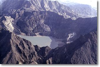
portion of the volcano and the formation of a 2 km-diameter crater.
The height of Pinatubo was reduced by > 300 m.
After June 16 the frequency and magnitude of eruptions declined.
Three minor eruptions/day occurred until the third week of July,
2 per day until mid-August, and 1 per day until the end of August.
Three eruptions were recorded during the whole of September, the
last on September 4. All of these eruptions produced mostly steam
columns < 16 km high and many were < 10 km. The alert level was
lowered to 3 on September 4 and then to level 2 on December 4. The
danger zone was also reduced from 20 km to 10 km radius on December
4.
Eruption impacts - general
Two cities and 61 towns in the three provinces surrounding the
volcano were declared calamity areas, affecting around 1.18 million
people. Casualties included 847 dead, 184 injured and 23 missing.
Of the dead, 281 died indirectly from effects of the eruption, 29
from lahars, and 537 died from diseases in the evacuation camps
(mostly the Aetas that lived on the volcano flanks before the eruption).
Damage to infrastructure and property amounted to hundreds of millions
of dollars.
Tephra fall and lahars affected > 86 000 ha of agricultural lands
and fish ponds. Irrigation systems, water supplies, power and communication
lines, roads, bridges, houses and other infrastructural elements
were damaged by lahars. Heavy tephra falls in conjunction with the
eruption earthquakes caused the collapse of houses and public buildings.
The cities of Angeles and Olongapo (Fig. 20) ceased their commercial
and industrial operations and Clark Air Base was evacuated. Around
651 000 people were forced out of work due to destruction of their
farms, shops and factories. Even Manila was affected by ash fall
resulting in the closure of the international airport for four days.
In Manila, a number of public buildings were used to house refugees
from the provinces closer to Pinatubo.
|
|