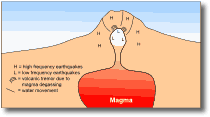
MonitoringVolcanic monitoring and eruption prediction A volcanic eruption does not occur spontaneously, but normally follows a series of precursory changes. Detection of these precursory effects and gaining an understanding of them prior to the subsequent eruptions can be used to develop empirical models for predicting eruptions. However, any predictions made are only probabilistic and must be acknowledged as such when predictions are made to authorities. Precursory phenomena Events and phenomena that often occur before an eruption may include seismic activity, ground deformation, hydrothermal phenomena, and chemical changes in gases etc. However, these events do not always occur before eruptions, nor do eruptions always follow these events. No perfect indicator of an impending eruption has yet been found. Nonetheless, monitoring and detection of such events helps to build a model of the way in which the volcano behaves and helps to formulate probabilities of an eruptive event occurring at a certain time. Seismic activity Frequent, shallow earthquakes often occur beneath a volcano preceding an eruption and are easily monitored and detected. A single seismometer located at or near the volcano, with a real-time signal relay to an observatory (by radio or satellite relay), is one of the best forms of continuous monitoring. Once activity is detected, further seismometers need to be deployed to form an array of at least five or six devices. This array enables determination of the depth, position and magnitude of the earthquakes and enables changes in these parameters to be monitored. From this data, the amount of magma rising to the surface through fractures, and its rate of rise can be estimated. Changes in the pattern of seismic waves and decreasing focal depths indicate the magma is approaching the surface. Earthquakes on volcanoes are generally different to those in non-volcanic areas and include high frequency (5-10 Hz), low frequency (1-3 Hz) and intermediate frequency events, as well as micro-earthquake swarms and long duration vibrations (harmonic tremor). High frequency events are the same as those in non-volcanic areas and indicate instantaneous fracturing in cold, hard rock. Low frequency events occur when the rock is hot and "soft", the higher frequencies are absorbed by the rock. Volcanic tremor is probably (although not known for certain) due to degassing of magma and the passage of gas through rock fractures. Micro-earthquake swarms (of tens to thousands of events) occur where the rock is weak and highly fractured, and are caused by repeated small movements on a fault segment. As magma rises to the surface, the pressure it exerts on the surrounding rock causes high frequency earthquakes (Fig. 19). As it nears the surface the pressure of overlying rock lessens and continuous or intermittent degassing occurs causing volcanic tremor. Sudden releases of pressure or interaction with groundwater causes low frequency earthquakes.
Ground deformation Large volumes of magma entering a volcanic edifice often cause it to swell or bulge in places even causing uplift of the edifice and its surroundings. At Usu volcano in Japan, a 1 km2 area rose around 200 m in 11 months, before being pierced by a lava extrusion. Also, prior to the climax of the 1980 St Helens eruption, a bulge of 1 km2 area grew on the volcano's northern flanks, growing outward at more than 1 m per day. However, in most instances, the amount of ground deformation associated with eruptions is a few mm per day and only detectable on precisely surveyed transects. Vertical movements are measured by optical levelling with survey equipment or with tiltmeters that record small changes in slope. Tiltmeters using water or mercury are the most accurate in detecting change, but cover a small area only - sometimes reacting to purely local influences. Measurement of lake levels can be used to detect uplift over larger areas, otherwise, standard surveying techniques and repeated surveys are often sufficiently precise to predict changes. Generally tiltmeter and optical levelling data complement one another. Continuous tilt recordings supply information on the rates of change, while optical levelling provides details of the pattern of deformation. Expansion of an edifice or area can be measured by horizontal displacement between fixed points using electronic distance measurement. An ideal network for monitoring ground deformation encompasses two dimensions and several points around a volcano. Interpretation of deformation data can be highly subjective and needs to consider many parameters including viscous and elastic rock deformation and the size and shape of intruding or withdrawing magma bodies. However, these techniques have proved valuable around Hawaiian volcanoes and White Island (New Zealand) as well as many others throughout the world. Hydrothermal phenomena The temperature and rate of water and gas emission from hot springs and fumaroles are easily measured indicators of the thermal state of a volcano. However, these are difficult to interpret because they depend not only on the state of the volcano, but also on rainfall and the way in which water circulates through the volcanic edifice. Observations of steam emissions are also highly misleading, being dependent on wind, relative air humidity and air temperature etc. Hydrothermal changes provide only indirect evidence of what is occurring deeply within the volcano, but can provide warning of the likelihood of an imminent phreatic eruption. At Usu volcano (Japan) increases in hot spring temperature occurred over 18 months prior to its eruption in 1977, coupled with an increasing frequency of local earthquakes. The temperature of crater lakes can be of greater significance. For example, the crater lake on Taal was 32.5-33oC from 1961 to mid 1965, by late July 1965 it had risen to 45oC. By September, when the water was at 43oC a violent eruption occurred. Chemical changes Between eruptions, gases from magma below a volcano can reach the surface through vents in the crater or on the volcano flanks. Chemical analysis of these gases can reveal information about what is occurring below. As gases such as SO2, H2S, HCl and CO2 rise to the surface they cool and are differentiated to some degree. Hence the temperature and chemical composition of the gases at the surface can give an idea of the magma depth. Changes in the relative concentrations of gases, particularly sulphur in relation to chlorine, can indicate that magma is approaching the surface. Fumarole gas temperatures may vary considerably. On White Island they have been measured at between 100 and 600oC during build-up to eruptions. However, large temperature increases do not always precede eruptions and give limited information on the timing of any eruptive climax. Gas compositions are measured on samples taken to the laboratory, or analysis of key species in the field, as well as sampling and measurements of volcanic sublimates. A common approach in the last few years is to measure volcanic gases rising from a volcano. COSPEC (correlation spectrometer) measurements from aircraft give valuable data on the amounts of SO2 production, and these surveys were used regularly throughout the 1995-1996 eruption of Ruapehu. Enormous gas releases of > 14 000 tonnes of sulphur/day were recorded at the time of the largest 1995 eruptions. Limitations of chemical techniques are that a variety of factors may affect the gases as they rise to the surface, and one gas sample may not be representative of the volcano-wide conditions. Large differences in gas composition are often observed in samples taken short times or distances apart. In addition sampling gases without contamination can be difficult. Although chemical analysis of volcanic gases and waters do not provide an immediate warning of volcanic activity they can be used as valuable indicators of the general state of a volcano. Chemical changes in the waters of Crater Lake on Ruapehu are used to indicate greater components of direct magmatic gas input into the lake and hence a rising body of magma. A greater Mg:Cl ratio is used to identify increasingly direct magmatic gas input. Other techniques The following techniques are not yet universally applied to monitored volcanoes and are in many cases still being developed. Magnetic
field strength Electrical
and electromagnetic methods Microbarograph
records of air waves Underwater
noise surveys at marine volcanoes and crater lakes Summary Although the individual methods of predicting volcanic eruptions are not always consistent or reliable, knowing the overall characteristics of a volcano's seismicity, deformation patterns (if any) and gas and water chemistry through continuous measurement, certainly helps to identify any unusual events that may precede an eruption. In the search for alternative prediction methods three criteria must be considered. Firstly, the lead time of the prediction must be enough to enable protection measures to be emplaced. Secondly, the time window of the prediction must be as short as possible, and thirdly the prediction must be reliable. The chance of a false alarm must be as low as possible. Triggering mechanisms of volcanic eruptions In the previous section the various techniques serve to describe changes before eruptions and to establish empirical links between these changes and the potential for an eruption. Another approach is to try to understand the actual physical and chemical mechanisms that trigger eruptions. This requires an estimation of the volcanoes internal behaviour based on evidence from external phenomena. Although an understanding of the triggering mechanisms is desirable, it is very difficult to interpret the internal state of a volcano from measurements of the external phenomena. In the following two eruption examples the difficulties in determining triggering mechanisms are discussed. Both examples highlight the problem inherent in the current methodologies for prediction of eruptions, where models are derived almost solely from statistical analysis (and pattern recognition) of observed data. Future methodologies should be concentrating on understanding of the physics and geochemistry of volcano systems. Nyiragongo (Zaire) Nyiragongo volcano is part of the western branch of the East African rift system. Since first observations in 1891 until January 1977 no activity has been observed outside the summit crater, although between around 1928 and 1977 a lava lake existed in the crater. The lava lake varied considerably in level over the time of its existence prior to eruption of the volcano in January 1977. During the eruption, the lava lake as well as lava in the feeding system were spread over 20 km2 through several lateral cracks in the NW and SE crater walls. Due to the high fluidity of the lava and the hydraulic head between the lava lake at 3370 m altitude and the cracks at 1770-2200 m, the eruption lasted only 30 minutes. A lava flowing to the southeast destroyed several villages and killed over 1000 people, to the northwest the lava spread widely without causing casualties. Five days before the eruption it was noticed that the lava lake level was very high, but, because it had also been this high in 1972 it was not considered dangerous. The volcano was not monitored and although earthquakes were felt before the eruption, the population was caught by surprise because earthquakes are common in this area. It was suggested that magma rising through the feeding system induced swelling to split the mountain. A rapid increase of magma pressure at depth would be required to cause several simultaneous lateral fissures. This magma pressure at depths of < 2 km was not balanced by an increased lake level probably because magmatic gases could not rise freely in the feeding system. As a result, the mixture of the two phases, magma and gas, reached a critical velocity where mass flow through the feeding system was choked and high pressures generated. Although volcanic earthquakes and an unusual tremor were recorded by a seismometer 100 km away, a monitoring system would have enabled location of the earthquakes and estimation of the deformation of the volcano. This in turn would have enabled prediction of the type of eruption. However, to estimate the timing of eruption would require, knowledge of the dynamic processes controlling the behaviour of magma, estimation of these processes for Nyiragongo, and consideration of the mechanical properties of the Nyiragongo rocks. Hence, the more that is known about the internal state of a volcano before an eruption the fewer the uncertainties of its behaviour and short term activity. This is particularly valid if the volcano departs from behaviour expected from past activity. Nevado del Ruiz (Colombia) The effects of the devastating 13 November 1985 eruption of Nevado del Ruiz were described earlier (section 3.3.5). The first signs of renewed activity at the volcano were recorded in 1984 and an explosion occurred on 11 September 1985, resulting in a minor ash fall and a 27 km-long ice and rock avalanche. The day before the climatic eruption no unusual behaviour was noticed at the summit. In the months preceding November 13, the most probable scenario for the eruption characteristics was based on an eruption of the volcano in 1845. In 1845 devastating mudflows were generated, inundating huge areas, including the site of Armero which was destroyed in 1985. Since the September eruption all were aware of the lahar danger to the surrounding areas if activity were to increase. In a preliminary hazard map lahars were expected in all valleys draining the glacier on Ruiz. However, although scientists and authorities knew what could happen they did not know whether or when it would happen. The only geophysical observations to answer the remaining questions of whether and when an eruption may happen were those of seismographs around the volcano since August 1985. However, due to the lack of background information on the seismic activity at Ruiz (including data of past pre-eruptive episodes) little information relevant for short-term prediction could be found by earthquake analysis. Low frequency earthquakes at Ruiz increased only after the main eruptions in September and November. However, certain types of volcanic tremor (with 15-20 minute episodes spaced at regular 1-1.5 hour intervals) were recorded on September 5 until the eruption on September 11. Bands of cyclic tremors also occurred a few days before November 13, but their significance was not recognised in time. This indicates the cyclic tremor signal may be useful for forecasting eruptions at Ruiz - although what causes them remains unknown. However, even after 1985 with an improved monitoring system on the volcano, eruptions in 1986 and 1989 could not be predicted. This example shows that where there is poor understanding of a volcano that has not been well studied, existing methods for short term prediction are inadequate. Even if the potential risks are well known, the question of when and whether an eruption may occur remain unanswered.
|
||||||
|
||||||