Volcanic Hazards: Introduction
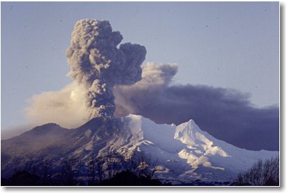
The greatest hazard is associated with strato-volcanoes found near subduction zones. These volcanoes may erupt violently at reasonable frequent intervals through geologic time. During eruption, large ash columns may be produced and winds will distribute tephra (volcanic ash and larger fragments) from these to great distances beyond the volcano, causing nearby towns and cities to be smothered in ash. Closer to the volcano, townships located near river valleys are in great danger from lahars or mudflows which are mixtures of ice, crater lake waters, ground water or rain water, and debris from the flanks of the volcano. Lahars travel down existing river valleys at high speeds pushing the river water ahead of them and causing extensive flooding and silting of river channels - which may lead to further flooding after the eruption. Lahars possibly account for the greatest loss of life. The most violent eruptions may produce hot pyroclastic flows which are turbulent mixtures of searing hot gases and tephra which move down the slopes of a volcano away from the vent. Pyroclastic flows are giant clouds of hot gases and ash particles formed by collapse of the buoyant ash column. They travel at tremendous speeds, too fast for anything or anyone to escape, and because they are so hot they incinerate everything in their path. These are the most fearsome events. Although on a global scale, the loss of life and property arising from volcanic eruptions can be quite small when compared with other natural hazards (such as earthquakes and tsunamis), at a regional level (i.e. within a country) losses from eruptions can be great. The communities at greatest risk are the remote rural villages located on river valley floodplains at the base of volcanoes. Such communities suffer direct impact from volcanic events and are usually totally devastated. The impact on such communities is well documented in accounts of eruptions at Nevado del Ruiz (Colombia) in 1975 and Mt Pinatubo (Philippines) in 1991 and 1992. Other famous eruptions worth reading about include the 1902 eruption of Mt Pelee, and the May 1980 eruptions of Mt St. Helens (USA). Communities located further beyond the volcanoes suffer less, but are still at risk from heavy ash falls and floods. Some of the effects of eruptions on communities include: collapse of buildings due to the weight of accumulating ash; damage to vehicles; burial of food crops by ash and mud; water pollution through sedimentation and acidification; fires (secondary hazard); and health problems (including disease and trauma). Improvements in technology over recent years have enabled scientists to more accurately monitor volcanoes, and in some cases, to predict eruptions. The ability to forecast and predict volcanic eruptions enables communities to take action before an event in order to minimise possible losses from impact, i.e. to mitigate the effects of an eruption. USGS scientists have now installed monitoring equipment on approximately 20 volcanoes around the world, mostly in developing countries. Using, for example, tiltmeters, seismometers, and EDM (electronic distance measurement) networks scientists are better able to identify precursors to eruptive activity and provide sufficient warning, in most cases, allowing for large-scale evacuations of densely populated villages around volcanoes.
Learning Outcomes This module is designed to acquaint you in a general way with the occurrence of volcanism on our Earth. It then introduces you to the myriad of volcanic processes that can occur during an eruption and the hazards they present to life and property. Based on a volcano's past eruptive history one can interpret the likely distribution and frequency of future volcanic hazards. This information can be effectively communicated to Civil Defence and the general public by the use of volcanic hazard maps and explanatory text. Some examples of volcanic hazards mapping are discussed. Techniques for monitoring and forecasting eruptions is another field for understanding in civil defence emergencies. A review of these techniques is included. To minimise the risk of volcanic damage there is much scientific research conducted into mitigation techniques. Practical protective measures designed to reduce volcanic risk provide another alternative. The
module concludes with mention of some famous historical volcanic
disasters followed by a case study of the June 1991 eruption of
Mt Pinatubo. Two exercises appear at the end of this module.
|
|||||||||
|
|||||||||