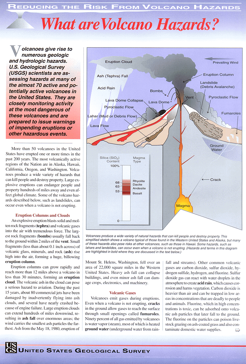
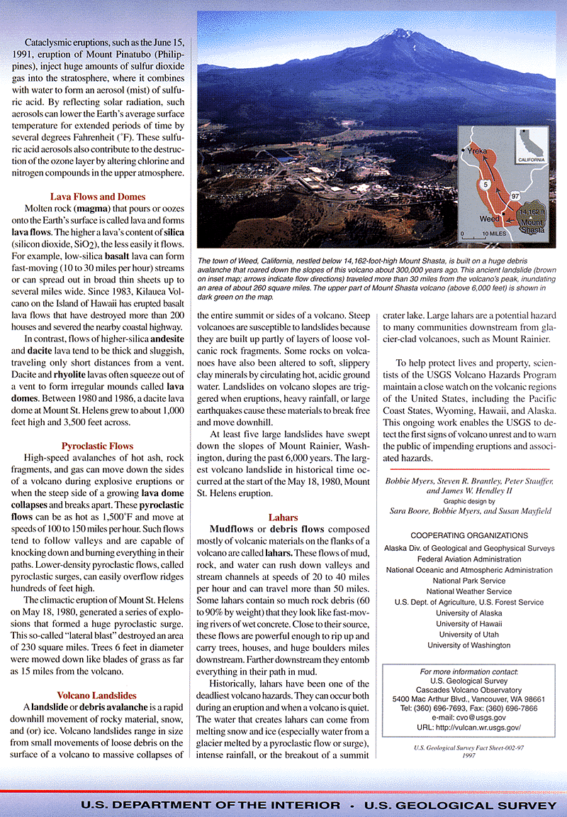
Volcanic Hazards
Pyroclastic Falls These occur where fragments of lava or rock fall back to earth after being thrown into the air by volcanic explosions or carried upward by an eruption column of rising gases. These air transported fragments are termed tephra and the process forms a pyroclastic-fall deposit. Pyroclastic-fall deposits may consist of combinations of pumice, scoria, dense lithic material, and crystals and may range in particle size from ash (diameter < 2 mm) through lapilli (2-64 mm), to blocks solid and bombs molten (> 64 mm).
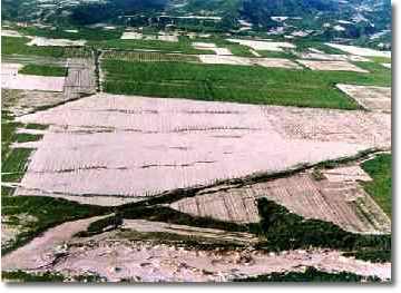
Plate 1. Food-producing fields of sugar cane destroyed by the pumice fall of Mt. Pinatubo in June 1991. - V. E. Neall.
Pyroclastic fall deposits may be heavy enough to cause the collapse of buildings and break telephone and power lines. Crops can be killed or damaged, and grazing livestock seriously affected, with effects ranging from excessive tooth abrasion to death by fluorosis. Ash clouds pose a serious hazard to all motorised traffic, particularly aircraft, damaging and clogging engines. Ash clogs guttering and waste water systems, and can infiltrate and damage or destroy electrical equipment. Ash can also cause physical (turbidity) and chemical contamination of water supplies. Pyroclastic falls can be potentially far more devastating if they are accompanied by or followed by rainfall. Ash on top of buildings can soak up large amounts of water and become much heavier - causing collapse of buildings that may have been able to withstand an equivalent amount of dry ash. Intensified rainfall runoff may also occur causing excessive erosion and generation of sediment charged floods or in some circumstances lahars. Very close to the eruptive vent (generally <10 km), ejected blocks and bombs can endanger people and property, although if low density scoria or pumice is ejected it can be less damaging. Occasionally pumice and scoria fragments > 10 cm in diameter can be hot enough to start fires when they fall. This hazard is greatest within a few kilometres of the vent. In 1973 fragments ejected from Heimaey in Iceland smashed though windows and ignited the wooden floors of buildings. Pumice fragments 20-30 cm in diameter started fires on wooden roofs up to 10 km from vent during the 1707 eruption of Fuji in Japan. Also, fires were started in forests and villages within 8 km of Agung on Bali during a 1961 eruption. The area affected by pyroclastic fall depends on the height of the eruption column, the volume of material ejected and the wind velocity and direction. Hazard from ash is proportional to its thickness and decreases downwind of the volcano.
Laterally directed blasts These events can be the most destructive of all volcanic phenomena. This is because they can occur within a period of a few minutes with little or no warning, can affect areas up to hundreds of square kilometres, and can kill everything in their path by impact, abrasion, burial and heat. People and animals are often also killed by inhaling hot gases and ash. Laterally directed blasts can be caused by sudden decompression of magmatic gases or a high-pressure hydrothermal system. Decompression can be via overpressure and explosive release or by unroofing of the pressurised body by a landslide or debris avalanche. The resultant blast can be directed upwards or at much lower angles, outward from the sides of the volcano. The most hazardous are those directed at angles approaching the horizontal or below it (i.e. down the slopes of a volcano). Transport mechanisms within these blasts may include a combination of ballistic ejection of rock fragments, pyroclastic flow, surge, and possibly other as yet unrecognised processes. Thus the term lateral blast denotes the overall event, even though it may involve more than one process. Deposits of laterally directed blasts may be indicative of one or more of the transport processes or in some cases evidence of transport mechanisms is obscure.
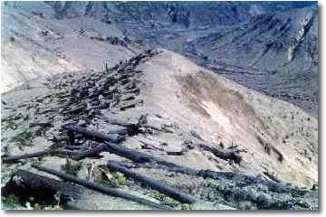
Plate 2. On Windy Ridge, Mount St. Helens showing fallen logs from former forest and stumps in lee of ridge (to left in distance), destroyed by the lateral blast on 18 May 1980. Note how the blast, travelling from right to left, removed all the vegetation and soil from the exposed right-hand side of the ridge. Half way down the ridge is a person for scale. - V.E. Neall
Laterally directed blasts can affect areas ranging between 1 to 100’s of square kilometres. In 1915, a lateral blast at Lassen Peak (U.S.) affected 10 km2, and one at Mt. St. Helens 1150 yrs B.P. affected around 40 km2. In contrast, the 1956 Bezymianny (Russia) blast involved 1 km3 of rock debris and devastated an area of 500 km2, and the 1980 St. Helens blast (with c. 0.2 km3 of rock debris) affected a 600 km2 area. The larger blasts were accompanied by partial destruction of the volcano, forming large horse-shoe shaped craters, open in the direction of blast.
Pyroclastic flows These are defined here as hot, dry, masses of particulate volcanic material and gas (mostly heated air) moving in contact with the ground surface. The term Pyroclastic flow includes a spectrum of volcanic events including: nuées ardentes or glowing avalanches, block and ash flows, and pumice flows. Pyroclastic flows contain hot volcanic clasts in contrast to avalanches of cold rock debris and other gravitational processes on the flanks of volcanoes. Pyroclastic flows generally comprise three main components: a relatively dense basal layer, one or more accompanying pyroclastic surges, and rising clouds of ash above the other two components. Basal flows are concentrated mixtures of ash to block- or bomb-sized fragments and gas whose movement is controlled by gravity. Hence the basal flows are controlled by topography, moving along depressions and valleys. Clouds of ash elutriated from the top of the other parts of the pyroclastic flow are dispersed by winds and deposited cool. Maximum temperatures in pyroclastic flow deposits are often between 350 and 550 oC. With greater distance from source, incorporation of air into the flow can reduce the temperature of flows. Hazards associated with pyroclastic flows include: asphyxiation, burial, incineration, and impact damage by the large fragments within the flow.
These flows contain predominantly hot to incandescent pumice, with subordinate lithic fragments, crystals and gases. Other names for these events are ashflows and pumice flows, and their deposits are often termed ignimbrites or ashflow tuffs. Many pumiceous pyroclastic flows are generated by the collapse of gas-rich vertical eruption columns or clouds, whilst others are formed by ejection and flow of an emulsion of frothy magma, accompanied by explosive activity. Pumiceous pyroclastic flows and deposits can range from 0.001-1000 km3 in volume, 200 km in length, and 20 000 km2 in area. Small pumiceous pyroclastic flows (Pumiceous pyroclastic flows of moderate volume (1-10 km3) can extend for tens of kilometres from volcanoes. At Mt. Mazama (U.S.) 7000 year-old flows extended 60 km down valley and one moved 213 m up a slope to cross a drainage divide at 17 km from source. A minimum velocity of 234 km/hr is required for the flow to climb this slope (assuming no friction, otherwise required velocity is around 350 km/hr). Other flows have crossed even higher barriers. The Ito pumiceous pyroclastic flow (Japan) extended 70 km from the vent and crossed 720 m-high mountain passes. The Campanian pumiceous pyroclastic flow (Italy) travelled 65 km and crossed many mountain passes up to 500 m high, and is found 1000 m higher than source at 50 km distance. Although very large pumiceous pyroclastic flows have occurred in the late Pleistocene and Holocene, none have occurred during historic time. Some prehistoric flows covered areas of 10 000 km2 with volumes exceeding 1000 km3. These flows travelled up to 150 km radially from source over topographic barriers >1000 m in topographic relief. Such a large flow would be an extreme hazard to a large region and economically crippling to many countries. Huge areas would need to be evacuated with even topographic highs being vulnerable, if not from the flow itself, then from associated surges and gases.
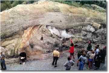
Plate 3. The pumiceous pyroclastic flow deposits of the Taupo Ignimbrite, dated about 1800 years before present, forming upper half of a forestry road cutting, east of Lake Taupo. Here the pyroclastic flow removed the top of the pre-existing ridge and dragged the underlying tephra beds into a huge overturned fold to the right of the spade. Follow the white pumice layer above the head of the man with the red jersey and note how it “swings back” on itself. The grey layer between has been folded on top of itself rather like a folded newspaper. Note also the drag “thrust” faulting in the beds to the left of the cutting. - V.E. Neall.
Rabaul volcano in Papua New Guinea has produced 3 small (<10 km3) low-aspect type flows in the last 4000 years and Taupo volcano has produced one with a volume of 30 km3 less than 2000 years ago. Pumiceous pyroclastic flows of low aspect ratio-type constitute an exceptional hazard because of their ability to surmount an entire landscape adjacent to a volcano, leaving little potential for refuge.
These are termed glowing avalanches, nuées ardentes, hot avalanches, or block and ash flows. These flows originate from; avalanches of hot material from a volcanic dome, vertical expulsion of material from a crater followed by fallback and flowage down the volcano flanks, and laterally directed explosions at the base of a dome. Pyroclastic flows formed in these ways are termed Merapi, St. Vincent and Peléean types, respectively.
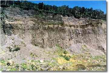
Plate 4. Exposures of block-and-ash flow deposits in Pyramid Stream, Egmont National Park. The lower two-thirds of the cliff exposure comprises deposits emplaced at high temperature about 9000 years ago. Above is 3 m of yellow-brown ash above which are units of the Maero formation deposited by hot block-and-ash flows over the last 500 years. The lowermost units of the Maero formation contain numerous charred logs from the pre-existing forest, whilst upper units contain mainly twigs and blades of tussock grasses dated at younger than 1750 A.D. Person in white shorts at top of scree to left for scale. V.E. Neall.
Pyroclastic surges These are turbulent, low density mixtures of rock debris, gases and sometimes steam or water, that move rapidly above the ground surface. Differing types of surges have been termed glowing clouds, ash hurricanes, base surges, ground surges and ash-cloud surges. Pyroclastic surges typically hug the ground and the controlling effects of topography depend on the surge velocity and density as well as the topographic relief. Surges originating on a volcanic cone can attain high speed on their descent of its flanks. Pyroclastic surges are subdivided into those which contain hot rock debris and those containing only cool or cold rock debris.
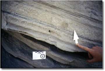
Plate 5. Dominantly surge deposits from Tepexitl tuff ring in the Mexican Highlands, 170 km east of Mexico City. Note the coarse sandy “pinching” deposits below, which were eroded by subsequent finer-grained surges, with a layer of accretionary lapilli marked by the arrow. - V.E. Neall.
These can be generated in several ways. Explosion of a volcanic dome by escaping gases under high pressure, or its disruption by a flank collapse can both generate hot surges which generally affect a narrow sector of a volcano. Also, the collapse of a vertical eruption column may be followed by radiating-outward pyroclastic surges. The spill over of an inflated mixture of ash and gases from a crater can also create surges down one or more flanks of a volcano. Hot surges can also be generated by a laterally directed blast; these can include both hot and cold rock and are contained within a 180 degree sector. Hot pyroclastic surges can occur alone or can accompany a pyroclastic flow of which they are a dilute, low-density facies. Such surges are more independent of topography than the basal flows. They generally move along the same general direction as the denser basal portion of the pyroclastic flow, but in some instances the surges can detach from the basal flows to travel on differing paths. Surges may also outrun and jet forward of a pyroclastic flow. The hazards of hot pyroclastic surges include damage of vegetation and structures, severe abrasion, impact damage by rock fragments and burial by ash and debris. People can be killed by asphyxiation, heat, presence of noxious gases and lack of oxygen. Only a strong windowless, fireproof structure could protect people in the path of a surge. The speed of surges can be so great that escape is impossible once the surge has been generated. Hence, zones at risk from these events should be evacuated before the start of an eruption that may generate pyroclastic surges. At the margins of pyroclastic flows, seared zones mark the extent of hot pyroclastic surges associated with them. The climactic 1951 eruption of Mt Lamington (Papua New Guinea) had seared zones up to 4 km wide surrounding the limits of the pyroclastic flows. All animals and most plants were killed within these zones.
These are also generally known as base surges and are generated by phreatic and phreatomagmatic explosions. The early stages of vertical explosions can produce a surge that radiates laterally from the vent unconstrained by topography. These surges have high velocities caused by the force of the explosion. Collapse of material from a vertical eruption column can also produce secondary pyroclastic surges, their velocity is due to gravitational acceleration as the material falls to earth and descends the volcano slopes. Cold pyroclastic surges contain varying amounts of water, particularly in their distal parts indicating a temperature <100 oC. The velocity of these flows ranges between 50-300 km/hr, but they tend to lose their energy quickly and typically stop within 10 km from source. Surges are modelled as being initially highly inflated, and cold surges probably fluidised by steam and air entrained during the collapse of an eruption column. As the surge cloud moves from the vent it deflates as air escapes and steam condenses. The energy of the cloud is dissipated by turbulence as well as friction with the ground and air, causing the solid components to settle. The hazards of cold pyroclastic surges are include destruction of structures and vegetation, severe abrasion, impact by rock fragments and burial by debris. As in the case of hot surges, their velocities are too high to permit escape. Hence, the only possible mitigation measures possible are to evacuate people from the zones likely to be affected prior to a potential surge-generating eruption and to avoid such areas for construction and occupation.
Lahars and floods Lahars and floods often accompany eruptions at snow-covered volcanoes and those with crater lakes. The largest floods resulting from volcanic activity are those in Iceland, where eruptions beneath glaciers cause melting and the generation of huge floods, termed jökulhlaups. The peak discharges of these enormous jökulhlaups can be at least 100 000 m3/s and reach 3-4 times this value. The most recent of these events occurred in early 1997. A lahar is a rapidly flowing mixture of rock debris and water (other than normal streamflow) from a volcano. The term is of Indonesian origin. Lahars can carry both hot and/or cold debris. Lahars that carry more than c. 60% by volume sediment tend to flow in a laminar fashion and are termed debris flows. Those with sediment concentrations in the range of c. 50-20% by volume have varying degrees of turbulent flow behaviour and are termed hyperconcentrated streamflows. Increasing sediment concentration in a lahar slurry and particularly large amounts of silt and clay-sized sediment enables lahars to attain very high yield strengths and cohesiveness. Hence, lahars can often carry very large masses of rock and sweep or carry away large man-made structures. Lahars can be generated in many ways both during and some time after an eruption. These generation mechanisms include: - Sudden drainage of a crater lake, either by explosion or collapse of a crater wall. - Entrainment and melting of ice and snow by passing pyroclastic surges and pyroclastic flows or by bombardment and fall of hot pyroclasts. - Entry and mixing of a pyroclastic flow into a river. - Movement of a lava flow onto snow and ice. - Avalanching of water-saturated rock debris from a volcano. - Fall of torrential rain on unconsolidated or fragmental deposits (particularly air fall tephra and pyroclastic flow deposits following an eruption). The largest lahar formed during the 1980 eruption of Mt. St. Helens was generated by remobilisation of a 2.8 km3 landslide deposit which had been emplaced for a few hours to at least 25 km from source. The lahar generated from the landslide deposit travelled for another 70 km downvalley. Devastating lahars were formed by melting and entrainment of snow and glacier ice by pyroclastic flows on Nevado del Ruiz in Colombia in 1985. These lahars claimed the lives of more than 23 000 people in towns more than 70 km downstream of the volcano. In New Zealand, failure of a portion of Ruapehu’s Crater Lake wall caused a lahar on Christmas eve 1953 which partially destroyed a railway bridge at 42 km from source. A passenger train fell into the lahar and 151 lives were lost. During the 1995-1996 eruptions of Ruapehu over 35 lahars were generated, 26 by explosive ejection of Crater lake water that entrained snow, ice and rock debris to form lahars. The remainder were formed by heavy rainfall on freshly deposited pyroclastic fall on the snow-covered volcano slopes. These rainfall-induced lahars are sometimes called secondary lahars or rain lahars in Indonesia.
Plate 6. The Kiosk building on the Whakapapa Skifield at Mt. Ruapehu following the eruption of 22 June 1969. Note the large size of the boulders picked up by the flowing sand and mud (lahar) that smashed the left wall, which collapsed, and later phases of the flow lapped up on the fallen roof. - V.E. Neall.
Velocities of lahars are greatest where the slope is steepest (i.e. on the flanks of the volcano) and decrease with distance from source. Factors such as channel width, solids:water ratio, and volume also affect lahar velocity. An avalanche of rock debris travelling at 180km/hr on Tokachidake volcano in Japan generated a lahar that travelled its first 24 km at an average velocity of 58 km/hr. Lahars caused by an eruption of Kelut (Indonesia) travelled their first 16 km at 65 km/hr. An extremely long lahar generated during an eruption at Cotopaxi volcano (Equador) travelled at an estimated 27 km/hr for 300 km. The 1980 St. Helens lahars were estimated to be travelling at speeds of >165 km/hr on the upper volcano slopes, however, downstream of the volcano average velocities were generally <25 km/hr. During the 1995-1996 Ruapehu eruptions, lahars on the volcano flanks were estimated to be travelling at speeds of>100 km/hr, but downstream of the volcano they travelled between 10 and 30 km/hr. Lahars affect population, agriculture and constructions on valley floors at great distances from a volcano. Even if people are aware of an eruption occurring they often consider themselves at no risk, being so far away from the volcano, particularly if ash clouds are blown in another direction. Due to their high density, lahars can displace and carry large and heavy objects, including cars, buildings and bridges. Burial of roads and destruction of bridges can often cut evacuation routes from affected areas. Build up of rock debris in river channels by lahars, reduces their capacity and often exacerbates the effects of later floods or lahars which are able to spread more widely and affect a larger area of valley floor. Lahars can also cause changes in the course of river channels, block tributary streams and create dammed lakes. Dikes, levees and other lahar retention structures can be built along river channels to mitigate the effects of lahars but these structures may be rendered ineffective by aggradation of the river channel, particularly in a series of lahars. Following the 1991 eruption of Pinatubo (Philippines) over 9 km3 of pumiceous pyroclastic flow deposits were emplaced surrounding the volcano. Remobilisation of these during the rainy seasons in the years since 1991 have produced hundreds of lahars which have built up and buried large areas of land including all retention structures built to contain them. Following lahars of the 1951 eruption of Kelut volcano the Indonesian government built an extensive system of diversion dams and lahar traps along the valleys draining the volcano. These structures are designed to limit the spread of future lahars across valley floors and to bring them to rest without causing damage. The costs of these types of constructions must be weighed up with the potential losses due to lahar inundation and passage. Hydroelectric reservoirs can be effective traps for lahars, but if they are full when a lahar enters, they can magnify potential hazards. On the basis of past lahars generated by Mt. St. Helens, it was recommended that 125 million m3 of storage capacity be made available if an eruption began. This did occur during the 1980 eruption and the dam was lowered by 7 m, a lahar of 13.5 million m3 entered the reservoir and caused its level to rise around 0.75 m.
Lava flows These rarely threaten human life because of their relatively slow motion and the degree to which their paths are controlled by local topography. If rates of lava emission and movement are determined, the flow arrival time at various localities can be predicted. Some lavas do flow rapidly, but these are normally confined to lava tubes or channels. Higher flow rates are associated with steeper slopes, greater emission rates and particularly fluid lava compositions. Extremely fluid basaltic flows at Nyiragongo volcano in Zaire in 1977 killed around 300 people living on or near it. This was caused by the sudden drainage of a lava lake in the crater that spread lava over a 20 km2 area in less than an hour. The flow had an extremely low viscosity with average depth being <1 m and velocities of 30-100 km/hr.
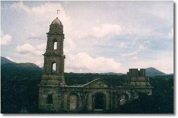
Plate 7. The church of San Juan Parangaricutiro, destroyed by a lava flow in June 1944, from the newly-formed Parícutin volcano in Central Mexico. The church lies at around 4.5 km from the vent of Parícutin. The lava flow travelled right to left in this picture, destroying the side walls of the church and leaving the front and rear walls standing. The remaining buildings in this town were poorly constructed from wood and were completely destroyed by the advancing aa lava flow travelling at c. 5 m per hour. - S. J. Cronin.
Lava flows cause total destruction in their paths by burning, crushing and burial. Burial of land by lavas almost always results in a very long term (near permanent in human terms) loss of agricultural production of an area. Lava flows that melt snow and ice also have the potential to produce destructive lahars and floods. Lava flows can also potentially start fires in heavily vegetated areas.
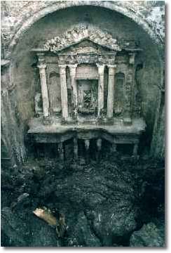
Plate 8. Altar of the church inundated by lava at San Juan Parangaricutiro. This church housed “The Cross of Miracles” which attracted pilgrims from the surrounding areas within Central Mexico. When destruction of the church seemed inevitable, the cross was removed to be eventually installed in a new church constructed in the relocated town, San Juan Nuevo. The altar stands c. 4 m high. - S. J. Cronin.
Volcanic domes and cryptodomes A volcanic dome is formed by the extrusion of highly viscous lava, which cannot flow more than a few hundred metres from the vent. Lava is generally extruded upward causing a mass of lava to inflate directly above the vent. As the dome inflates and when it reaches a maximum height of a few hundred metres it becomes increasingly unstable. Avalanches and rock falls frequently occur down its sides, some caused by gas release explosions and others by movement of the dome. Merapi-type pyroclastic flows may be generated from the flanks of growing domes and impact up to 10 km from source. Domes can grow near the summit of a volcano, anywhere on its flanks, or even in areas surrounding it. Domes grow rapidly, many reach their maximum size and become dormant within a year. Following the climactic eruption of Mt. Lamington (Papua New Guinea) in 1951, a dome began to form, initially growing up to 30 m per day. Pyroclastic flow-generating explosions decreased its size and alternated with periods of further slow dome growth until 1955. A dome was also extruded following the 1980 St. Helens eruption and continued to grow and partially collapse until 1983. During the 1990-1995 eruption of Mt Unzen (Japan) a dome sporadically grew. Between 1991 and 1994 over 9000 Merapi-type pyroclastic flows were generated by collapse and explosions from the dome, causing the deaths of 44 people. Domes that form on or beyond the base of a volcano can damage and destroy man-made structures, but their principal hazard is due to pyroclastic flows and ballistic rock fragments thrown out by explosions. Cryptodomes are those that grow beneath the ground surface, and these pose less hazards than many other volcanic events. However, a sudden unroofing of a cryptodome on the flank of Mt. St. Helens precipitated an explosive and destructive eruption. Unroofing of cryptodomes may result in the eruption of pyroclastic material or lava. The composite cone of Usu volcano (Japan) has several cryptodomes on its flanks in addition to one in its crater. A cryptodome grew during 1944 and after the ground surface rose 50 m a fissure eruption began on top of the newly formed mound, the dome rose to 150 m high and was later followed by extrusion of a 100-120 m high lava dome on top in 1945. Cryptodomes associated with Mt. Misery on St Kitts (West Indies) uplifted coral reefs up to 100 m above sea level. Near Bazman volcano (Iran) three cryptodomes formed by basaltic intrusions have uplifted Quaternary gravels by 60-100 m in an area of monogenetic volcanism. In the mapping of volcanoes it may be possible to delineate areas where domes and cryptodomes are likely to occur. The potential hazard zones associated with these features needs to take into account the range of laterally directed blasts, ballistics and pyroclastic flows derived from a future growing dome.
Phreatic explosions These explosions are due to the superheating of water or steam rather than resulting from magmatic eruptions. Phreatic explosions are common at composite volcanoes which are by nature composed of alternating layers of permeable (and thus water holding) and impermeable strata. Within these volcanoes, water movement can be restricted and if heat is applied, water can be superheated until the vapour pressure rises enough to exceed the confining lithostatic load. This results in a steam explosion which is generally followed by a progressive release of super-heated steam which is accompanied by rock debris from the walls of the explosion conduit. Phreatic explosions may ballistically eject large rock fragments and produce ash clouds. A series of phreatic explosions at Kilauea volcano (Hawaii) in 1924 ejected around 800 000 m3 of rock debris. These explosions were probably the result of groundwater entering the conduit of the volcano along fractures caused by a sudden subsidence of the crater. Tectonism associated with ascent of magma may cause rock fracturing and the rise of superheated waters from depth, increasing vapour pressures and causing phreatic explosions, even if no magma is ever erupted. This occurred at Soufrière de Guadeloupe (West Indies) in 1975-1976 where seismic activity built up to 19 phreatic explosions which ejected a mixture of steam at around 100oC, and old rock debris. If magma rises into a volcano, it may cause heating of water within the cone and generate phreatic explosions. Before the cataclysmic 1902 eruption of Mont Pelée (Martinique) weeks of phreatic explosions occurred. Phreatic activity also preceded the 1980 St. Helens eruption. On some volcanoes a constantly high heat flow causes intense hydrothermal alteration of rocks as well as phreatic explosions. The hydrothermally altered rocks form an impermeable cap causing the build-up of vapour pressure and producing the conditions necessary for phreatic explosions. Purely phreatic eruptions grade into those which involve varying amounts of magma, these are termed phreatomagmatic eruptions. Some eruptions along a fissure, such as the 1886 Tarawera eruption (New Zealand), are magmatic at points where the water content of rocks was low (e.g. on the Tarawera massif itself) and phreatic in topographically lower areas (e.g. at Lake Rotomahana).
Volcanic gases Magmas contain varying amounts of gases dissolved within them, these are released during the ascent and eruption of the magma. Volcanic gases mostly comprise water vapour, CO2, CO, and variable amounts of S, Cl, F, H and N. Carbon monoxide is toxic, and even though CO2 is not, it can commonly dilute or displace oxygen and cause asphyxiation. Both of these gases are heavier than air and odourless, they tend to flow down slope and collect in depressions killing unsuspecting people and animals. In Java in 1979, phreatic eruptions in the Dieng Mountains released gases, including CO2 and H2S, that moved downslope to kill 145 residents and 4 rescue workers trying to evacuate by foot. In 1986 over 1700 people died during a sulphurous CO2 emission from the Nyos crater in Cameroon. SO2 and SO3 are common toxic volcanic gases and can be detected easily by their strong odour; SO2 rapidly oxidises in air to form sulphuric acid. Hydrogen sulphide (H2S) is also detectable by its odour at low concentrations but at high concentrations when it can be an irritant or cause asphyxiation it becomes odourless. Nitrogen combines with hydrogen to form ammonia, which although toxic, tends to form less harmful compounds. Volcanic gas compounds are emitted and transported as acid aerosols, films on tephra particles, and microscopic salt particles, in addition to their gaseous form. Volcanic gases can affect health and life as well as damaging crops and property. Acidic components of gases affect eyes, skin and the respiratory systems of animals and people. Some gases (e.g. SO2) kill vegetation although the effects are highly dependant on gas concentrations. Sulphurous gases emitted from Masaya volcano (Nicaragua) at times seriously damage coffee and other crops up to 40 km from the volcano. Acid rains caused by the mixture of raindrops and aerosols and gases can cause skin irritation and fabric damage as far as 2000 km from source. Airborne gases are rapidly diluted in air to sub-toxic concentrations, usually within 10 km of the volcano. In rare cases of extreme gas release over an extended period very serious regional effects can occur. In 1783, Lakagigar volcano (Iceland) erupted large amounts of HCl, SO2, CO2, and F with ash fall. This caused a haze that persisted for months, killing and damaging vegetation over the entire island, and contributing to the death of 50-70% of the livestock. More than 10 000 human deaths occurred in the resultant famine. A haze of fine ash and gas affected Europe and other parts of the Northern Hemisphere, causing a detectable effect on climate.
Tsunamis Although most tsunamis are generated by large sea floor earthquakes, some types of volcanic events can trigger them as well. At Unzen volcano (Japan), volcanic earthquakes in 1792 triggered a huge landslide into a shallow bay. This generated a tsunami with wave heights up to 10 m that killed >14 500 people. During the violently explosive eruptions of Krakatoa (Indonesia) in 1883, most of the 36 000 fatalities were caused by huge tsunamis with waves over 30 m high. The tsunamis were likely to have been generated by collapse of part or all of the volcano, local subsidence of the sea floor, and pyroclastic flows entering the sea. Other cases of volcanically triggered tsunamis are discussed in the Tsunami study guide for this course.
|
|||||||||||||||||||||||||||||||
|
|||||||||||||||||||||||||||||||