Mt Pinatubo 1991 Eruption
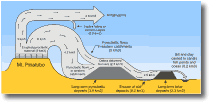
Tarlac River system The upper portion of the Tarlac catchment (to the north of Pinatubo) stored a relatively large amount of potential lahar source material (Table 11), but experienced limited effects from lahars. This was partially due to natural retention features in the upper O'Donnell and Bangat valleys, where large amounts of pyroclastic flow deposits were emplaced in broad flat valleys, upstream of bedrock valley constrictions. In addition these catchments are in the rain shadow of the Southwest Monsoon. However, the potential for destructive lahars remains, especially during typhoons, due to the large amount of pyroclastic-flow deposits remaining in the upper catchment. Bambam River system The Sacobia River is the most active tributary of the Bambam, and had 0.6-0.9 km3 of pyroclastic deposits in its upper reaches. In 1992 a secondary pyroclastic flow caused erosion between the Abacan and Sacobia Rivers, allowing the Sacobia to capture part of the Abacan flows. From 1991-1993 around 0.2 km3 of sediment was deposited along the Sacobia River. 1991 flows reached 40 km from the volcano near Concepcion (Fig. 20), inundating 90 km2 of farmland and low-lying communities adjacent to the river. Intermittent damming of the Sacobia's tributaries led to several temporary lakes forming. Breaching of one of these lake impoundments contributed to a lahar that destroyed a highway bridge across the Bambam. Accumulation of sediment in the lower reaches of the Sacobia River led to aggradation further upstream in 1992-1993. Numerous lahar avulsions and lake-breakout floods occurred burying parts of the towns of Mabalacat and Bambam in 1992 and 1993. Another secondary pyroclastic flow occurred in the headwaters of the Sacobia in 1993, filling the channels and diverting subsequent flows towards the Pasig-Potrero River. This resulted in no lahars in 1994 in the Sacobia and much reduced sediment remobilisation. Abacan River system Portions of the headwaters of this river drain parts of the upper Sacobia valley, which produces many lahars. However, other portions of the headwaters drain only tephra-covered slopes, leading to flooding and sediment discharge but no lahars. A large dike was constructed to prevent avulsion into Angeles City in 1991. More than 40 lahars occurred in the Abacan River during the 1991 monsoon season as well as at least one during the eruption. These lahars destroyed all of the bridges across the Abacan upstream of Mexico and caused bank collapses that destroyed hundreds of buildings in Angeles City. Overbank sediment deposition downstream of Angeles City covered around 25 km2 in 1991, especially near Mexico. Pasig-Potrero River system The Pasig-Potrero drains the southeastern portion of a large fan of pyroclastic flow deposits on the eastern volcano flanks, and has 0.3-0.5 km3 of potential source material. From 1991-1993 around 0.14 km3 of material has been eroded and redeposited downstream. The 1993 secondary pyroclastic flow in the Sacobia headwaters increased the Pasig-Potrero watershed and contributed to a further 0.13 km3 of sediment deposited along the Pasig-Potrero in 1994. Monsoon lahar activity in this river system was high in 1991 and two lahars also occurred during the eruption. Lahars avulsed flood control levees and inundated around 10 km2 of agricultural land as well as contributing enormous quantities of fine sediment that silted up canals and fish ponds. From 1991-1994 channel aggradation moved upstream to cause frequent avulsions near Mancatian and Porac, which continued in 1995. Lake breakouts during this time transported sediments further downstream toward Bacalor. Typhoon Kadiang in July 1995 caused dilute floods and incision of a channel. Successive floods continued to deepen and extend the channel downstream, moving sediment further downstream to slowly bury the town of Bacalor. Five successive lahars generated during Typhoon Mameng in October 1995 inundated around 25 km2 and killed up to 100 people in a part of Bacalor.
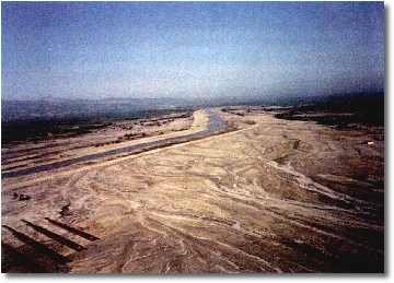
Plate 11. The Porac River at Porac. Note how the river has aggraded to the level of the bridge (in the distance). Pumiceous sediment has been bulldozed from the channel to create stop-banks alongside homes evacuated after lahars partially destroyed them. - V. E. Neall.
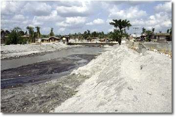
Plate 12. Aerial view of the Pasig-Potrero where since 1991 lahars have continued to overflow the channel and bury the town of Bacalor in sediment. A two storied building is visible to the right. Despite the efforts of hundreds of pieces of earth-moving machinery it was not possible to build stop-banks large enough to contain the rapidly aggrading river bed. - V. E. Neall.
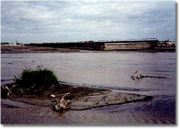
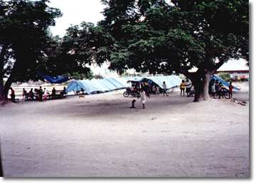
Plate 13. Along the main highway from Manila to Clark Air Base, near Los Angeles, where decking of the bridge was swept away by lahars following the Pinatubo eruption in 1991. - V. E. Neall. Gumain River system Large rain-induced lahars occurred in the Gumain and Porac rivers during the 1991 eruption, burying houses in Floridablanca and Porac to roof level. After further lahars later in the year only an estimated 20-40 % of potential lahar source material remained in the upper catchment. Aggradation in the mid-lower reaches of the Gumain in 1991 resulted in the river bed being 4-5 m higher than the surrounding alluvial fan, being currently contained between flood control levees. Widespread fish pond and canal siltation also occurred during 1991 in the lower reaches of the Gumain. Santo Thomas River System Between June-November 1991, 73 lahars were recorded in this catchment to the SW of Pinatubo. The Santo Thomas drains a 1.3 km3 1991 pyroclastic-flow deposit fan (the Marella Pyroclastic Fan). Both hot and cold lahars have occurred in this catchment. The hot flows originated from rainfall remobilisation of pyroclastic-flow deposits and the cold ones from breakout of dammed tributaries in the upper catchment. In 1991 a temporary lake (Lake Mapanuepe; Fig. 25) was developed up to 19 times, each time ending with a lake-breakout flood that transformed to a lahar. These lake-breakout lahars flooded large downstream areas, destroying homes and claiming at least one life. Repeated lahars until the end of 1994 have deposited > 0.5 km3 of sediment over an area of > 46 km2, burying seven communities and threatening several others. Lake Mapanuepe, was still in existence at the end of 1995 and its continued rise necessitated cutting of an artificial outlet, to maintain a lower lake level and minimise the potential for catastrophic floods. At its highest level, the lake covered an area of 14 km2, containing around 200 million m3 of water (20x the volume of Crater Lake on Ruapehu). Maloma River system The Maloma River drains only a small area of pyroclastic flow deposits and does not have the potential to produce as many lahars as other river systems surrounding Pinatubo. However, some cold lahars have occurred, including a large event during the eruption. These completely filled the Maloma channel with sediment by the end of 1991 so that the river flowed through rice paddies to the sea. Bucao River system The largest volume of pyroclastic deposits (2.5-3.1 km3) fills the upper catchment of this river, forming a steep valley-fill deposit covering the north and northwest volcano flanks. A large mass failure of these deposits caused a 10 km-long secondary pyroclastic flow in 1991. Major lahars did not occur in this catchment until the 1991 monsoon season, but sediment had totally inundated the lower Bucao valley in up to 25 m of sediment by the end of 1991. Later lahars threatened the town of Botolan. Socio-economic effects of the Pinatubo eruptions Not only have lives been lost during the Pinatubo eruption and following events, but also major damage has been sustained to the infrastructure and economy of central Luzon. The 1991-1992 damage alone amounted to over US$460 million. Damage to crops, agricultural land, personal property and infrastructure still occurs years after the eruption was over, disrupting what was a flourishing economy. Major resources have been diverted from key development activities to relief, recovery and damage prevention measures. The Costs to support evacuees and for lahar dikes and sediment retention structures over the 1991-1992 period amounted to around US$ 150 million. In fact the longevity and magnitude of the eruption's impacts are so great that return to pre-eruption conditions is impossible. Responses must be to create an environment for new investment, alternative employment and promote growth in areas safe from lahars and to develop infrastructure able to withstand future natural disasters. The eruption effects have resulted in displacement of >50 000 people whose houses were destroyed and/or farmland buried. The Aeta peoples formerly living on the slopes of Pinatubo were initially hardest hit, although later, people on the surrounding lowlands also began to be seriously affected. Evacuations have also resulted in upsetting social standings and leadership, caused suspicions between neighbouring communities, and resulted in high levels of psychological stress. Resettlements have also created similar problems, and humanitarian relief is becoming a way of life for many people.
|
||||||
|
||||||