|
||||||||||||||||||||||||||||||||||||||||||||||||||||||||||||
|
|
||||||||||||||||||||||||||||||||||||||||||||||||||||||||||||
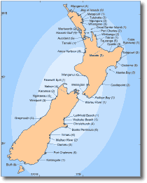
Tsunami Hazard in New ZealandNew Zealand lies in an active seismic area on the edge of the Pacific Ocean and therefore is potentially at risk from tsunamis of local and distal origin. Earthquakes from anywhere between the southern coast of Chile to the Aleutian Islands are capable of producing potentially damaging tsunamis in New Zealand. The Kermadec Trench and Mayor Island are other potential source areas for New Zealand tsunamis. Seismic activity within the Tonga-Kermadec region could generate local tsunamis, however, the direction of wave travel (perpendicular to trench lineation) would divert energy away from New Zealand shores. The possibility of tsunami generation from submarine faulting following or accompanying a large tephra eruption at Mayor Island should also be considered. Locally generated tsunamis could also result from sufficiently large earthquakes in coastal areas. Reports of waves and surges followed several large N.Z. earthquakes, such as the 1855 Wellington, 1922 Rangiora and 1931 Napier earthquakes. Regions at highest risk from tsunamis are those on the east coast, from the Bay of Plenty to Akaroa. Tsunamis transmitted from points around the Pacific Ocean may impact along these eastern shores. Tsunamis from South America, particularly Chile, possibly represent the greatest distal hazard. A few north Pacific tsunamis have reached New Zealand to be recorded on tide gauges, but waves have generally been less than 1 m high. Since 1848, New Zealand has experienced 15 tsunamis, including small, locally generated events (Fig. 14, Table 4). Compared to other Pacific countries, New Zealand has escaped lightly from both their occurrence and effects. The three largest events affecting New Zealand within the last century were all sourced off the coast of Chile. Tsunami waves arriving in the New Zealand region following the 1868 Chilean earthquake caused 1 confirmed drowning (and probably a few others) in the Chatham Islands as well as the destruction of the Maori settlement of Tupunga. Surges were also recorded in many New Zealand ports. The 1960 Chilean tsunami was recorded by tide gauges in the Wellington, Lyttelton and Otago harbours. The 1964 Alaskan tsunami was also recorded in Lyttelton harbour. In addition, local historians record a possible tsunami that engulfed and swept away a large party of Maori near Otara in Southland in the early 1800's.
New
Zealand is surrounded by an extensive continental shelf, and energy
reflected at the continental slope and enhanced frictional loss
on the shallow shelf probably diminish most of a tsunami's energy
before it reaches the coast. In contrast, Japan and Hawaii are not
protected by large marginal shallow sea floors and suffer the full
effect of Pacific-generated tsunamis. Table 4. Tsunamis experienced in New Zealand (data from de Lange and Healy, 1986).
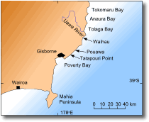
The only clear instance of a damaging local tsunami on the mainland of N.Z. was in March 1947, when a tsunami originating off Gisborne caused damage to coastal settlements along the nearby coastline. This part of the coastline was affected by a smaller tsunami again in May 1947. In addition, on 20 May 1987 a slip in Doubtful Sound (Fiordland), caused a 2-3 m high wave that lifted a launch onto its wharf, destroying the structure in the process. The March 1947 New Zealand tsunami The 25 March 1947 tsunami, generated off East Cape, was preceded by a moderate earthquake with a magnitude of 6.0. However, other evidence suggests that the earthquake itself was not the cause of the tsunami, but that a gas blow-out on the sea floor may have been the cause. The earthquake was centred in an area of sea floor that is penetrated and fractured by diapiric intrusions. These have from time to time explosively expelled mud and breccia originating at a depth of several kilometres. The muds and gases are expelled from circular pit-like structures, which appear to be structural equivalents of mud volcanoes found in the onshore Gisborne region. Several spectacular mud eruptions have occurred in the Gisborne region. In one such eruption (1908) mud was ejected to 120 m high, and approximately 153 000 tonne of material was expelled. The occurrence of similar underwater events could easily give rise to tsunamis. An origin by gas emission and disturbance of the sea floor is consistent with observations by Gisborne residents of the sea foaming during the earthquake. The area is now known to be diapirically active and marked by concentrations of circular explosion pits. The March 1947 tsunami affected a 120 km section of the Poverty Bay coastline, between Anaura Bay and Mahia Peninsula (Fig. 15). Most of the damage occurred at Pouawa, and between Waihau and Tatapouri.
The
first wave of the tsunami struck the coast at 9:05 a.m. At Tatapouri
Point, the wave struck the Tatapouri Hotel at the level of the windows,
around 4 m above high tide. The hotel was extensively damaged, and
inside the building, waves deposited sand, seaweed and fish. I stopped 50 yards up the road from the Tatapouri Hotel and saw the crest of the first big wave sweep in, rolling over the sand dunes in front of the hotel, and swiftly envelop the lower floor of the building. Outhouses were lifted off their foundations and disintegrated in the swirl which sucked the ruins of the buildings back over the beach and out to sea. The first wave was quickly followed by two or three more. The second wave was estimated to be 10-11 m above normal tide level. Along the entire coast waves were greater than 4 m in height. Bores which travelled up some of the northern coastal rivers (e.g Pouawa River) damaged wooden bridges, sweeping materials several kilometres upstream. In the later May 1947 tsunami, waves did not reach the Hotel. The tsunami struck during low tide, with wave heights < 4 m. Areas of the coastline affected by the earlier March 1947 tsunami suffered only minor damage.
|
||||||||||||||||||||||||||||||||||||||||||||||||||||||||||||
|
||||||||||||||||||||||||||||||||||||||||||||||||||||||||||||