|
||||||
|
|
||||||
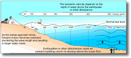
Mechanisms of Tsunami FormationSubmarine Faulting The most common event that generates tsunamis is submarine faulting which causes part of the ocean floor to be thrust upwards. Because an earthquake and tsunami result from the same fault movement, tsunamis are often referred to as "seismic sea waves", and the earthquakes as "tsunamigenic earthquakes". The abrupt submarine faulting and vertical displacement of the sea floor causes rapid displacement of the overlying water column, and forces it into a wave-like turbulence. This turbulence is expressed as a series of seismic sea waves (Fig. 1).
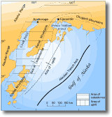
Most seismic activity beneath the oceans is concentrated in the narrow fault zones adjacent to the great oceanic trench systems (subduction regions). Hence, most tsunamigenic earthquakes originate in areas adjacent to the ocean trenches, e.g. the Aleutian Trench (south of the Aleutian islands) and the Atacama Deep, west of Chile. Only a small number of submarine earthquakes result in tsunamis. Most have a small spatial effect or are too low in magnitude to cause vertical displacement of the ocean floor. Generally, only those earthquakes with a Richter magnitude of 6.5 or greater, and shallow focal depths (< 50 km), are likely to be accompanied by tsunamis. The largest recorded tsunamis were generated by submarine earthquakes of magnitude 8.5 that had large spatial effects. Very large areas of ocean floor (> 100 km2 ) were displaced by several metres in these events. The largest tsunamis are those associated with elliptically-shaped ground displacements, i.e. the sea floor uplifted is in the approximate shape of an elongated ellipse. In both the 1960 Chilean and 1964 Alaskan events (discussed in section 5), the length of permanent ground displacement parallel to the fault line was 800-950 km and the width, perpendicular to the fault, was around 150 km. In plan view, the perimeters of the uplifted areas can be approximated by an ellipse (e.g. Fig. 2).
Energy is radiated from the centre of the ellipse in a direction perpendicular to its long axis, with the long axis almost always parallel to the nearby ocean trench. Hence, most tsunami waves travel in a direction perpendicular to the trench systems.
Historical accounts of eruptions at many of the world's coastal volcanoes attribute much destruction and loss of life to tsunamis generated during the volcanic eruptions. Of those killed during volcanic eruptions, nearly 25% have died as a result of tsunamis. Many historical tsunamis were once thought to have been generated by volcanic eruptions. It is now considered that submarine tectonic earthquakes generated most of these, although earthquakes may also generate eruptions. A good example is the 1930 eruption of Stromboli. An earthquake, accompanied by a sharp 1 m uplift and rebound of the island, took place an instant before the climactic explosions. The resulting tsunami reached 2 m in height. The vast majority of tsunamis of true volcanic origin are attributed to debris avalanches or landslides entering coastal waters. Other important mechanisms of generating volcanic tsunamis include: pyroclastic flows impacting on water, submarine explosions, and caldera collapse or subsidence. Less important causes include lava flows and lahars entering the sea. The largest of the volcanic tsunamis are generally due to destructive processes such as subsidence and disruption of lava domes and emplacement of pyroclastic flows, rather than constructive processes (e.g. submarine cone building eruptions and lava flow extrusion). In only a few instances have tsunamis been attributed to the flow of lava into the sea. One of the most famous accounts of tsunami generation associated with a volcanic eruption is that of the 1883 eruption of Krakatoa. The Krakatoa eruption was responsible for one of the worst natural disasters in history. Tsunamis were generated that swept the low-lying coasts of Sumatra and Java, drowning at least 36 000 people. Waves estimated at 35 m high arrived at the shores. Most of the lives lost during the eruption resulted from the tsunamis and not from erupting ash and pyroclastic avalanches. Tsunamis of similar magnitude can be expected in any future cataclysmic eruption of an island volcano. The origins of the Krakatoa tsunamis have long been debated, but were probably generated by multiple origins including: subsidence or collapse of the main island during caldera-forming explosions, submarine explosions, and pyroclastic flows and avalanches entering the sea. Many small sea waves recorded are thought to be air/sea coupled waves produced by explosions, and are not true tsunamis. Tsunamis associated with large slope-failure events can extend the impact of an eruption well beyond the volcano itself. A 0.5 km2 volcanic debris avalanche, generated on the slopes of Mt Unzen (Kyushu, Japan) during eruptions in 1792, swept through the town of Shimabara and into the almost enclosed waters of the Ariake Sea. This initiated a 10 m high tsunami which affected the low-lying parts of Shimabara. Most of the 10 000 casualties in the city resulted from the tsunami. The tsunami also swept opposite coasts, killing a further 4300 people. The tsunami travelled at an estimated 40 km/hr, which would enable only a 30 minute warning to the communities on the far side of the Ariake Sea. Tsunamis caused by debris avalanches entering the sea have also affected coastal communities on the Japanese main islands. Dangerous tsunamis are expected to be generated following any future large debris avalanches from the slopes of Sakurajima volcano. Such avalanches are expected to enter Kagoshima Bay (southern Kyushu) and generate tsunamis. A tsunami hazard also exists where lakes occur in close proximity to volcanoes. Wave runup at Spirit Lake from the 1980 Mt. St. Helens debris avalanche reached a height of 200 m. Submarine landslides Many of the world's damaging tsunamis are known to have been caused by submarine and subaerial avalanches displacing water in relatively confined coastal bays or harbours. Submarine landslides were common in Alaskan harbours during the 1964 Alaskan earthquake (section 5.3) and were the cause of local tsunamis along the Alaskan coastline. Other causes It has recently been postulated that tsunamis may be generated in areas of the sea floor where gas expulsion or seepage pits occur. These structures, up to 20 m wide and 1-2 m deep, emit water and natural gas derived from underlying intrusions. The subaerial equivalents of these structures are mud volcanoes and mud pools which are found along faults and in areas of diapiric upwelling (i.e. where there is an upward injection of material through the surrounding strata). Mud volcanoes and pits generally have a similar form and dimensions to those on the sea floor, and also emit gas and saline water. Numerous sea floor pits occur in the offshore Gisborne-Poverty Bay region, and are thought to mark sites of potential tsunami generation. Two New Zealand tsunamis (25 March 1947, and 17 May 1947) were generated in an area of sea floor off Gisborne. This area is penetrated and fractured by diapiric intrusions that have occasionally exploded mud and breccia originating at a depth of several kilometres. The March 1947 tsunami was probably caused by diapiric intrusion and gas blowout on the sea floor. An earthquake accompanied the tsunami, but due to its low magnitude (<6), it was not considered to be a tsunamigenic earthquake. During the earthquake, a Wainui resident reported seeing the sea froth. Foaming of the sea is consistent with disturbance of the sea bottom and shelf sediments with emission of gas during explosive mud volcanism.
|
||||||
|
||||||