|
|||||||||||||||||||||||||||||||||||||||||||||||||||||||||||||||||||||||||||||||||||||||||||||||||||||||||||||||||||||||
|
|
|||||||||||||||||||||||||||||||||||||||||||||||||||||||||||||||||||||||||||||||||||||||||||||||||||||||||||||||||||||||
Case Studies
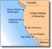
The 28 March 1964 Alaskan tsunami On 28 March 1964, one of the largest and most severe earthquakes ever recorded in North America struck Alaska, with a Richter magnitude of 8.4. The quake caused displacement of a vast area of ocean floor (estimated to be 2/3 of the area of California, see Fig. 2), and both uplift and subsidence on the mainland of Prince William Sound. The movement of the ocean floor generated a major Pacific-wide tsunami which swept the coasts of Alaska, Canada and California. Numerous smaller tsunamis also affected the coastal regions of Alaska, with most of these caused by landslides entering the sea. The landslide-generated tsunamis were locally disastrous, but the major tsunami waves that swept the Pacific coasts of both Alaska and California ultimately caused the most death and destruction. More than 120 people lost their lives and damage was placed at US$ 100 million (see Table 3).
The first two waves that struck the Crescent City coastline caused no loss of life and only minor flooding and damage. However, the third and fourth waves were much larger and considerably more destructive. Those residents who had not evacuated were overwhelmed by the waves which razed and flooded much of the city.
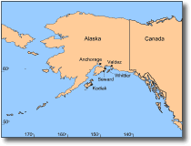
On the Alaskan coast, the townships of Seward, Kodiak, Whitter and Valdez (Fig. 11) were struck by both the major tsunami and locally generated tsunamis. They suffered extensive tsunamic damage as well as the effects of earthquake-induced landslides.
The first waves that hit Seward were from a locally generated tsunami caused by landsliding. These were followed by the major tsunami, the first wave of which was 10-13 m high as it neared the head of Seward Bay. Eighteen lives were lost at Seward. Ground shaking ruptured sewerage and oil pipelines and valves of waterfront oil storage tanks. Overturned tanks slid into the bay and fuel pouring from them exploded, covering the sea with burning oil. Flaming tsunami waves arrived ashore, setting the waterfront buildings alight and engulfing the downtown area. The impact of the waves destroyed homes, docks and port facilities. Boats were driven through buildings, and highway bridges linking Seward with the Kenai Peninsula were destroyed. The backwash then carried railway cars, boats, piers, houses and vehicles out to sea. Kodiak also suffered extensive damage from the effects of the earthquake and tsunamis. The coastal region subsided some 1.5-2 m, thereby increasing Kodiak townships vulnerability. Low-lying areas of the town were inundated by a series of 10 tsunami waves, whose amplitudes were enhanced by the rising high tide. The first wave to arrive at Kodiak caused minor flooding and damage. However, the second wave was about 13 m high. This wave destroyed most of the structures and buildings that had been previously weakened by the first wave and its backwash which had undermined foundations. Hundred-tonne fishing boats were washed over the breakwater and as far as 3 blocks into town. Over 40% of Kodiaks business and 30% of its fishing industry facilities were destroyed. The fishing fleet which remained moored in the small harbour was also destroyed.
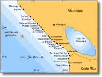
The 1 September 1992 Nicaragua tsunami On the 1st of September 1992 a magnitude 7.0 earthquake occurred off the Pacific coast of Nicaragua (Fig. 12). The earthquake generated a tsunami with waves 8-15 m high that struck 26 communities along the Nicaragua coastline, leaving 116 people dead, 63 missing and 489 seriously injured in its wake.
The tsunamigenic earthquake was very shallow and was accompanied by a submarine landslide. This produced a rapidly moving tsunami that arrived at the coast only 20 minutes after the earthquake. The tsunami struck in the evening, hence most fishing boats were docked (or beached) and subsequently lost or destroyed in the waves. Other damage included 2 schools together with tourist centres and facilities. In addition, the area suffered severe ecological effects. Salt water incursion to many coastal wetlands destroyed plant and fish life, as well as turtles and their eggs. The town of El Transito (Fig. 12) was one of the most completely devastated, almost all of the towns houses were swept away or destroyed. The first wave to arrive was small and provided a short warning to the villagers, most of whom fled to higher ground. Later waves reached 9 m high, inundating and destroying the village. Of a population of 1000, 16 were killed and 151 injured by the tsunami. Of those killed, 14 were small children and 2 were elderly men; these people were unable to escape quickly enough after the first wave. Huge waves inundated 1000 m inland at the village of Maschapa (south of El Transito). Fifteen people were swept away or killed at this site. Following this tsunami there were further serious after-effects. Waves caused the flooding of sewerage into water wells. This water contamination resulted in an outbreak of cholera that spread along the coastal communities.
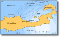
The 12 December 1992 Flores Island tsunami On 12 December 1992 a 15 km-deep magnitude 7.8 earthquake occurred just off the northern coast of Flores Island (Fig. 13), in the Indonesian archipelago. Over 2080 people were killed and 2144 injured by the combined effects of the earthquake (and its aftershocks) and a resultant devastating local tsunami (around half were attributed to the tsunami). The earthquake caused a sudden uplift of a huge area of sea floor; its modelled area and orientation is indicated in Fig. 13. The long axis of this uplifted region runs northeast-southwest. It produced a tsunami with waves travelling in a northwest-southeast direction. The waves heading southwest caused most of the damage, impacting on the coasts of Flores Island and the small islands off its northern shores. The tsunami had huge run-up heights, measured in places up to 26.2 m, and caused some unusually severe damage. Overall, 28 118 houses, 985 school buildings, 307 mosques, and 493 business buildings were destroyed. Over 90 000 people were left homeless. At Maumere on Flores Island (Fig. 13), 90% of the buildings were destroyed by the combined effects of the tsunami and earthquake. Tsunami waves reached 25 m high, advancing 300 m inland, and contributed to around half of the 1490 fatalities. In the nearby village of Wuhring, tsunami runup heights were only 3.5 m, but waves swept over the heavily populated 400 by 200 m peninsula, inundating the community. Although damage of structures was not as bad as other areas, around 100 people were swept away and drowned.
The effects on Babi Island were just as severe, but the location of the damage was unusual. The northern side of the island, directly exposed to the full force of the oncoming tsunami waves, escaped major damage. A broad tidal flat behind an extensive coral reef broke much of the tsunamis impact. However, it was the southern side of the island, in the lee of the tsunami travel direction, that suffered the greatest losses of the entire area. Waves reflected off the northern coast of Flores Island before crossing the deep 2 km straight to strike the southern coast of Babi. The southern coast has only a small coral reef and tidal flat that offered little protection from the reflected waves. Two communities were struck on southern Babi, and 700 people were killed with a further 100 missing. The communities of Pagaraman (Christian) and Kampungbaru (Moslem) were sited either side of a small tidal flat. The runup height ranged between 4.5 and 5.6 m in the area. No trace of Pagaraman remained and beach sand covers its former site. The first people to arrive on the scene were met with the gruesome sight of human remains suspended in tree branches. The entire village of Kampungbaru was also erased with much of the debris and human remains pushed into a low coconut grove, behind the former village site. This tsunami demonstrated how devastating a local tsunami can be. With the first waves arriving 5 minutes after the tsunamigenic earthquake, there was no chance to provide warning to at-risk communities.
|
|||||||||||||||||||||||||||||||||||||||||||||||||||||||||||||||||||||||||||||||||||||||||||||||||||||||||||||||||||||||
|
|||||||||||||||||||||||||||||||||||||||||||||||||||||||||||||||||||||||||||||||||||||||||||||||||||||||||||||||||||||||