|
||||||||||
|
|
||||||||||
Case Studies
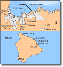
The 1946 Aleutian tsunami The April 1946 Aleutian tsunami was generated by a magnitude 7.8 earthquake, occurring near the Aleutian trench. Tsunami waves damaged coastal areas of Alaska and, because of its direction of travel, also struck at Hilo Bay in Hawaii. Near source, the waves are estimated to have been travelling at c. 780 km/hr, with wavelengths of approximately 160 km. Five people were killed by the tsunami on Unimark Island (in the Aleutians) by a 30 m-high wave. The tsunami struck Hawaii at 7 a.m., inundating Hilo Bay, and causing the deaths of 173 people in coastal communities. In earlier years, advance warning of approaching tsunamis (with warnings based on the occurrence of earthquakes) had been given. However, in each case, either a tsunami did not eventuate, or the waves that arrived at Hawaiian shores were less than 1 m high and considered insignificant. Hence, people began to disregard the tsunami warnings, believing they were false alarms. As a result of this, the people of Hawaii were caught completely unprepared for the 1946 tsunami. The greatest destruction and loss of life occurred on the coastal strip running along the Hilo bayfront, north of the Wailoa River (Fig. 9). Here, 96 people died, with a further 16 fatalities at Laupahoehoe, north of Hilo. The toll in human lives could have been much higher. At 7 a.m. most people were at least awake, although still at home. Had the first wave arrived an hour earlier, many people would have been caught asleep in their beds. An hour later, people would have left home for the day and downtown Hilo would have been filled with workers and shoppers. In either case the loss of life would have been much greater. The densely built bayfront business district of Hilo was almost totally destroyed by waves, which swept more than 600 m inland. Cocoanut Island (Fig. 9), located a small distance offshore was inundated by waves that reached 8.5 m above the normal water level in Hilo bay. Wave heights of more than 19 m above normal water level were also recorded. The withdrawal of the waves between crests exposed the sea floor for a distance of 170 m below the normal strand line. Piers, breakwaters, boats, railroads, bridges, coastal highways and buildings suffered extensive damage. A bore that advanced up the Wailuku River sheared a steel railroad bridge from its supports and washed it 250 m up river. The 1.6 km-long breakwater that protects Hilo Harbour from normal ocean waves was almost completely destroyed.
From their home on Pukihae Street, situated atop a 30-foot-high (c. 10 m) sea cliff overlooking Hilo Bay, Kapua Heuer and her family saw the events unreel before them. Kapua was busy preparing for the day's activities when suddenly one of her daughters asked, "Mommy, what's wrong with the water?". They all went to the cliff's edge at the end of the yard and saw that the sea floor was becoming exposed as the water withdrew. Far out at the breakwater the outward flow met an incoming wave, and the whole mass of water rushed toward the shore. Instinctively, Kapua and her daughters stepped back - just in time. As the wave collided with the sea cliff, water splashed over the tops of their coconut trees. Then the crash of the arriving wave mingled with the sound of walls and buildings being crushed as the wave struck downtown Hilo. The ocean was filled with debris and people who struggled in the waves that continued to flood into the bay. At each retreat of the water more flotsam filled the bay, accompanied by a loud sucking sound as if the ocean drank Hilo's offerings. Safe atop the sea cliff, but unable to help, Kapua watched the struggles of the victims and the destruction of the bayfront. This tsunami was an important event because it resulted in the creation of the Pacific Tsunami Warning Service.
The Pacific-wide 22 May 1960 Chilean tsunami
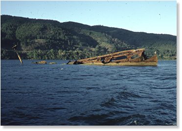
Sunday, 22 May 1960, was a day of terror for the South American country of Chile. The city of Concepcion had been rocked by sizeable earthquakes throughout the day and night, including a huge quake measuring 8.6 on the Richter Scale. Reports from Chile on May 22 told of destructive waves along the coast of South America and that a local, if not Pacific-wide tsunami had been generated. The magnitude 8.6 earthquake had indeed generated a Pacific-wide tsunami, threatening South America, Japan and Hawaii. The effect on South America The southern and central region of Chile suffered extensive damage and at least 1000 deaths from the earthquake and resulting tsunamis. All provinces within south-central Chile were affected by the earthquake, but the greatest damage was to coastal settlements which suffered additional damage from tsunamis generated by the earthquakes. Effects on coastal districts (e.g. Concepcion, Arauco, Puerto Saavedra, and Tolten) from both seismic and tsunami events included; flooding of lowlands with sea water, subsidence of unconsolidated sediments, generation of landslides, subsidence and uplift of the coastline, salination of the soil water table, and damage sustained by direct tsunami impact. Damage to roads, railroads and telegraphic installations virtually isolated south-central Chile from the rest of the country. In the city of Valdivia, 60% of the central buildings were destroyed, mostly as a result of landsliding of weakly consolidated alluvial sediments upon which the city is built. Many of the landslides resulted from liquefaction of weathered volcanic ash layers interbedded with the alluvial gravels. Lowland areas suffered inundation by sea water as a result of subsidence. Coastal regions of the city suffered great damage from tsunamis. Waves inundated a 500 m wide coastal strip to a depth of 0.6 m, and entered the estuary of the Rio Trufun. As the waves advanced up the narrow river valley they gained in height, destroying homes beside the estuary. At Tolten, north of Valdivia, the greatest damage was from the earthquake itself. Much of the coastal region suffered subsidence and subsequent flooding by tsunami waves. The main tsunami swell broke against a sand spit, giving protection to the city from the full impact of the waves. The waves were only able to breach the lowest-lying parts of the spit, much of their energy being expended by impact with the spit and passage across a 2 km coastal plain behind it. The resulting effects of the tsunami were described as being similar to a rising tide. The wreck of a 3500 tonne ship "Canelos" that was sailing off the coast of southern Chile when the tsunami struck in May 1960. Waves carried the ship 5km up the sound of the Rio Calle-Calle where it became grounded in the shallows. Although Tolten escaped the direct impact of the tsunami, much of the low coastal lands near Tolten were flooded with salt water. The flooding and ground shaking associated with the 1960 seismic activity caused compaction of the peaty soils around Tolten, and considerable structural damage to these soils. As a result, drainage of the lowlands was impeded and parts of Tolten remained under 1 m of water. Unlike Tolten, the town of Puerto Saavadra (north of Tolten), was almost completely destroyed by tsunami waves. The third and fourth waves of the tsunami wave train were the most damaging. Many wooden buildings, weakened by the earthquake, were destroyed by surging waves, which inundated the town to a depth of 3-4 m. The effect on Hawaii In Hawaii warning of a possible tsunami was given. Most people were informed that the tsunami was expected at about midnight. However, many did not understand the warning because the system of warning sirens had been changed a few months before. To add to the confusion, radio reports from Tahiti on 22 May said that the waves were small and a Honolulu radio station stated that no waves had yet arrived at Hilo, even though geologists had witnessed waves passing up the Wailoa River (Fig. 9). As in 1946, many of Hilo's residents were caught unprepared. The 1960 tsunami was catastrophic. The waves had travelled the 10 500 km from Chile in 14 hours, with a calculated mean velocity of 754 km/hr. The first wave reached Hilo at 12:07 am, surging into the township. The second wave toppled the seawall of downtown Hilo and flooded the heart of the business district and low-lying parts of Hilo township. The third wave developed a c.7 m high bore and advanced onto the town at c. 50 km/hr, causing extensive damage. As in 1946, the city of Hilo suffered the most extensive damage with a total of US$24 million destruction on the Hawaiian coast. The business district along Kamehameha Avenue (Fig. 9) and the adjoining residential areas of Waiakea and Shinmachi were literally wiped off the map. Despite advance warnings from the tsunami authorities, 61 lives were lost. Only 40% of the population had been evacuated. When the first wave struck, many were asleep; others heard the warning but failed to respond, and still others went down to the shore to watch the tsunami arrive. The following eyewitness account (extracted from Dudley and Lee, 1988) describes the events on that night in Hilo:
|
||||||||||
|
||||||||||