|
||||||
|
|
||||||
Mitigating The Effects
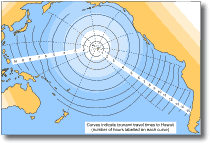
The Pacific Tsunami Warning System was established in 1948, in the wake of the 1946 Aleutian tsunami which devastated parts of Hawaii. This particular event provided the impetus for scientists to develop an improved warning system that would provide both reliable and adequate warning of approaching tsunamis, at least for the Hawaiian Islands. Prior to 1946, tsunami warnings in Hawaii were based solely on earthquake detection within the Pacific region. However, because many of the earthquakes did not generate tsunamis, the population grew complacent toward the warnings, and the system ultimately failed. The new system adopted a similar approach, but with one major addition. A network of tide stations were set up so that tide gauge readings can be used to confirm whether a tsunami has actually been generated. The warning system was established by the U.S. government, and its headquarters (the Pacific Tsunami Warning Centre) established at Honolulu, Hawaii. The system is now a co-operative program among many nations around the Pacific. The headquarters is a specially equipped seismological observatory that receives information about major earthquakes in the Pacific region, evaluates the earthquake's tsunami potential (using the epicentre and magnitude), and determines through tidal gauge measurements if a tsunami has been generated. The system pre-supposes that a magnitude 6 or greater earthquake is needed before a tsunami is likely to be generated. The vast majority of Pacific-wide tsunamis are caused by severe faulting on the sea floor, and an earthquake of magnitude 7 or greater. When a major earthquake occurs, it is recorded by seismographs all over the world within minutes. A seismic alarm is given if an earthquake of magnitude >6.5 occurs anywhere in the Pacific. Using the seismic records sent to the Tsunami Warning Centre, the magnitude and epicentre of the earthquake can be determined within 30 minutes. If the earthquake is strong enough to cause a tsunami and if the epicentre is located close to the ocean, a Tsunami Watch is declared. A tsunami watch is automatically declared for magnitude 7 or greater earthquakes.
Transmission times range from 10 minutes to 1 hour, depending on the efficiency of communication relay points. The tsunami arrival time at any particular place can be predicted with a reasonable degree of accuracy, allowing enough time for people to evacuate threatened regions. It is possible to forecast the arrival of a tsunami at Hawaii within minutes of an earthquake occurring, and several hours before the tsunami strikes.
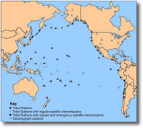
The Pacific Tsunami Warning System works well for tsunamis of distant origin, but is limited in its capacity to provide warning of locally generated tsunamis. Hence, principal member countries have been encouraged to set up their own tsunami warning centres to guard them against locally generated tsunamis. Chile, Japan and Alaska have done this using monitored systems of seismometers and tide gauges. Local tsunami warnings in these systems may be issued on the basis of earthquake information alone. The Chilean navy and the Japanese Meteorological Agency take responsibility for issuing more detailed warnings for locally generated tsunamis. In recent years, Chile, with help from the U.S., has significantly upgraded its disaster preparedness efforts. Chile has installed a tsunami warning system used to trigger evacuations along the Chilean coast within minutes of an offshore earthquake. In Japan there are five tsunami forecast centres responsible for spotting tsunamis in nearby seas and issuing tsunami warnings. Similarly, the Alaskan Regional Tsunami Warning Centre, established in 1967 (following the devastating 1964 Alaskan tsunami), provides watch and warning for locally generated tsunamis. Prior to the 1964 event, there was no warning procedure for locally generated tsunamis. This centre has an active programme of informing Alaskan residents about the dangers from local earthquakes and tsunamis. New Zealand is one of the many member countries belonging to the Pacific Tsunami Warning System, and although at relatively low risk from Pacific-generated tsunamis, it receives information about earthquakes occurring in the Pacific that might produce tsunamis. The possibility of a locally generated tsunami affecting the east coast of New Zealand is well recognised. Success of the Tsunami Warning System in mitigating hazard The Tsunami Warning System is the first of two steps in developing a warning system for the Pacific countries. While this system provides each region with the information it needs to assess whether it is at risk from a Pacific-generated tsunami, each of the Pacific countries must develop a system to communicate the warning to the public. The ultimate success of the Tsunami Warning System in mitigating tsunami hazard within the Pacific region hinges on the efficiency of the second programme. A country with a well instructed, readily executable warning system can take full advantage of the time made available to it, before a tsunami strikes. On the other hand, a poorly planned means of response can spell disaster. In the case of the 1960 Chilean tsunami, although the Tsunami Warning System was operative, the people of Hawaii suffered far more than they should have. This was simply due to confusion over the warning signals developed to convey the tsunami warning to the public. The system had warned of the approach of the waves as well as accurately predicting their arrival times. However, it was evident that public education as to the nature and seriousness of the tsunami was totally ineffective. During the 1952 and 1957 tsunamis, large numbers of people failed to leave the danger areas when told to do so. Instead, sightseers converged on the coast. Thanks to the small size of the waves, there was no loss of life. However, because these two events caused no damage, residents grew complacent toward tsunami warnings, and behaved little differently during the 1960 warning. Only 32% of the population evacuated after receiving a warning, and more than 50% waited at home for more urgent instructions, until it was too late and the waves struck. The most serious problem was that the public had only vaguely understood how the warning was to be given, and how they were to respond to it. The main reason for this arose from the fact that only months before, the system of warning signals had been changed, with an inadequate programme established to help residents understand the new system. Means of mitigating tsunami hazard Land use changes and protective structures Many of the coastal communities which have been repeatedly affected by tsunamis have adopted plans for redevelopment of their waterfront regions to minimise the loss of lives and property. The townships of Kodiak (Alaska) and the Sanriku region in Japan are examples of two communities that have undertaken major changes to reduce the impact and effects of tsunamis. At Kodiak, the region devastated by the 1964 Alaskan tsunami has now been regraded and a 120 m wide coastal strip filled to approximately 8 m above the previous level, and reinforced by an embankment. The strip has not been developed for housing, but instead has been set aside as a parking area. However, potential problems exist in that the filled area will likely subside during future earthquake activity, and will probably be severely scoured by tsunami waves. In addition, oil storage tanks located on the fill have not been secured and both oil and gas pipe lines presently run through the fill. Also, although houses have been relocated beyond the coastal strip, most are not built to withstand tsunami wave impact. Even though efforts have been made to reduce the risk, it would appear that the overall risks in Kodiak are actually greater now than they were in 1964. In 1896, a tsunami generated by a nearby earthquake struck the Sanriku district of Japan (several hundred kilometres north of Tokyo). The maximum wave runup was approximately 30 m, and thousands lost their lives. In 1933, another major tsunami was caused in the region by a local earthquake, killing about 3000 people and causing major property damage. Again in 1960, the Sanriku district suffered when waves from the 1960 Chilean tsunami struck the coast. Waves flooded the centre of the city of Ofunato to a depth of several metres, resulting in 199 deaths and damage of US$50 million. After the great disaster of the Sanriku tsunami in 1933, people in villages sustaining damage were recommended to re-establish new housing sites on higher ground, with assistance from a government subsidy. Later events, especially the 1960 Chilean tsunami have led to the development of a local tsunami warning system, changes in land use for the bay front area, and implementation of large protective structures. After the 1933 tsunami, the Japanese Government enacted a special law to subsidise 80% of the construction costs for restoring villages and constructing new tsunami sea walls. All construction work was completed in 1966, although few had been completed by the time of the 1960 tsunami. The construction of some was suspended due to financial difficulties, and many were too small to mitigate the effects of the 1960 event. An 8 m high seawall has since been constructed along the bay front area of the town of Taro, behind the fishing harbour, which has its own breakwater. Also, a massive tsunami breakwater was built across the entrance to Ofunato Bay. It took five years to build, and was planned in response to the 1960 tsunami. Several kilometres north of Ofunato, a similar structure was built at Kamaishi to protect the local steel industry and fishing fleet. By constructing breakwaters, the heights of the sea walls surrounding the townships could be reduced, thus improving the appearance of waterfronts and access between towns and ports. However, large sea walls remain where breakwaters cannot be constructed due to cultural fisheries located in the harbours. In addition to implementation of protective structures and changes in land use management, a warning system has been developed which now allows efficient evacuation of the bay front area. However, despite efforts made to protect communities of the Sanriku region, many people are now again living on the dangerous low land near the shore, because of population increases and shortage of safe land space. For this reason, tsunami walls now surround most villages on the coast. The city of Hilo in Hawaii has approached tsunami protection differently. After sustaining damage from the 1960 Chilean tsunami, Hilo conducted a study (the Kaiko's Project) to define the best means of protection against similar events. The most economic solution was to create a buffer zone near the coast that encompassed the area inundated in 1960. A landfill plateau, 8 m in height, was constructed in the buffer zone and the central business district relocated behind this. Houses were elevated above the potential wave height, with walls and columns of the basement or ground floors designed to resist impact forces of tsunami waves. Abandoned high risk sites were converted to parkland (e.g. the strip between Kamehameha Avenue and the bayfront, (Fig. 9), and planted in trees to afford extra protection by acting as a sediment and debris trap. Coupled with this, a local tsunami warning system was established to provide advance warning of approaching tsunamis. Most protection programs implement both changes in land use and structural protection works, such as sea walls and breakwaters. However, the cost of such structures, and the degradation of natural seascapes by them restricts their use. Many coastal communities have opted for the less costly alternative of coastal land rezoning. Mitigation strategies for all coastal communities should be aimed at reducing the vulnerability of buildings by establishing protective structures as a first means of defence, and using tsunami-resistant building materials to minimise secondary hazards (e.g. fire and flooding). Harbour installations, especially piers, can be built to withstand the effects of impact, ensuring proper reinforcement of structures (oil tanks, harbour buildings). Also by restricting sites where these can be located, the amounts of debris arising from wave impact can be greatly reduced to minimise secondary hazards. If sufficient time is available, boats should be sent out to sea to save property loss and to reduce the amount of floating debris generated during tsunami impact at the shore line. Land use planning commonly involves establishing buffer zones and should take into consideration the need to locate public assets, such as hospitals, schools, and emergency services away from those areas likely to be inundated. Hazard mapping and numerical simulation Hazard maps, depicting maximum tsunami wave runup in coastal regions are a necessary part of hazard planning and mitigating the effects of tsunami hazard. Numerical models are used to simulate the generation, propagation and effects of a tsunami at a shoreline. This information is needed to; construct hazard maps, define flood hazard zones, evacuation areas, and areas needing shore protection works. Most models are complex computer-based mathematical simulations into which are given the generation characteristics of a tsunami (e.g. location, area of sea floor displacement and ocean depth), to predict the effect observed at the shore. Such models take into account the effects of bathymetry, sea floor topography, tides, coastal geography, and wave refraction on tsunami speed, wave heights and shore line runup. The accuracy of such models in predicting the effects of tsunamis at a shoreline has been tested using data collected from known tsunamis and their effects. In most instances the anticipated effects (e.g. runup heights, travel times) are in good agreement with actual events. Hazard maps depicting tsunami arrival times and wave runup have been prepared at a scale of 1: 63 360 for the Hawaiian Islands and the Californian coast.
|
||||||
|
||||||