|
|||||||||||||||||||||||||||||||||||||||||||||||||||||||||||||||||||||||||
Measuring and RecordingEarthquakes
are measured in two different ways, (1) magnitude
of an earthquake is a measure of the absolute amount of energy released
at the focus of an earthquake and (2) the intensity
of an earthquake is the effect felt at the surface of the earth.
Different mathematical formulae are used to calculate earthquake magnitude depending on the extent of the quake, the depth of its focus, and the distance of the epicentre from recording seismographs. The different magnitude ratings that result are critical to understanding earth processes at an advanced scientific level, but are of little value to the general public because no magnitude rating indicates the destructiveness of an earthquake. For example, the 1993 California and the 1995 Kobe earthquakes had similar magnitudes, but in California 53 people died whereas the Kobe earthquake caused 5300 deaths, mainly because of differences in local soil conditions, regional geology and type of house construction. Furthermore, Japan has had 26 earthquakes this century of greater magnitude than Kobe but only one of them caused more deaths. Figure 11. 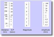 The
concept of an earthquake magnitude was first proposed by Charles Richter
in 1935 (Rahn 1986). The Richter magnitude scale was designed to measure
the total amount of energy released by each shock wave produced by
shallow earthquakes up to M 6.5 in California and "Richter
magnitude" is defined as the log10 of the amplitude
in microns of the largest displacement on a seismogram located
100 km from the earthquake epicentre (Rahn 1986). In reality such
a precise location is unlikely (short of installing hundreds of seismograms
throughout the countryside), and stations closer to the epicentre
are used; Richter magnitude being calculated using a nomogram (Fig.
11). The
concept of an earthquake magnitude was first proposed by Charles Richter
in 1935 (Rahn 1986). The Richter magnitude scale was designed to measure
the total amount of energy released by each shock wave produced by
shallow earthquakes up to M 6.5 in California and "Richter
magnitude" is defined as the log10 of the amplitude
in microns of the largest displacement on a seismogram located
100 km from the earthquake epicentre (Rahn 1986). In reality such
a precise location is unlikely (short of installing hundreds of seismograms
throughout the countryside), and stations closer to the epicentre
are used; Richter magnitude being calculated using a nomogram (Fig.
11). Media reports that persist with "Richter" scales are of little value to people wanting to know how bad the damage is, and how people are coping. Seismologists seldom calculate Richter magnitudes and only use the Richter scale when compelled to by news media. Seismologists prefer to use the local magnitude, ML scale when advising reporters. ML is only accurate for relatively close, small and shallow earthquakes, with foci < 15 km deep, and epicentres no more than 600 km distant. The ML is the logarithm of the maximum trace amplitude, in microns. The maximum trace amplitude of an earthquake of magnitude 4.0 at a distance of 100 km from a seismograph is 10 mm. Every time the amplitude increases by a factor of 10, the ML increases by 1. So, the maximum trace amplitude of a magnitude 5.0 earthquake 100 km from the seismograph is 10x larger. A body-wave magnitude, Mb is used to assess the energy given out from deep, but smallish, earthquakes, by measuring the largest amplitude of the body wave pulse. It is the most accurate way to determine earthquake magnitudes < 6.0 with foci > 60 km deep. A surface-wave magnitude, Ms measures the largest amplitude of surface waves propagated by large and shallow earthquakes, such as those originating in ocean trenches which are felt worldwide. It is not suitable for deep earthquakes which do not generate surface waves (Rahn 1986; Aitken and Lowry 1995). A major short-coming to accuracy in assessing the magnitude of an earthquake is the size of the rupture through a rock mass. Earthquakes begin at a point of weakness, but then this break propagates in a two-dimensional manner as a fault plane. Large earthquakes will rupture right up to the surface where displaced ground levels follow the direction of the rupture. This offset is known as the fault trace and where the length of this rupture is much greater than the wavelengths used in calculating a magnitude, the scale is "saturated"(Aitken and Lowry 1995). As a result, magnitude is not a very useful measure for earthquakes with surface ruptures over hundreds of kilometres in length. A more physically based magnitude called the moment magnitude, Mw, has been used over the past 20 years. Mw is a function of the area of a fault's rupture surface, the strength of a rock, and the amount of offset. It is preferred by seismologists because, although it takes longer to calculate, it can be used for earthquakes of all sizes and depths. In practice, however, Richter magnitudes are used for public consumption because of their perceived meaning.
The intensity of an earthquake is based on a subjective measure of the felt and observed effects of ground shaking on people, infrastructure (e.g. buildings and bridges) and natural features (e.g. trees and ground surface). The most used measure, the Modified Mercalli Scale (Table 1) comprises an escalating 12 -point scale of increasing levels of earthquake effect from (I) virtually imperceptible effect to (XII) catastrophic effect. Figure 12. 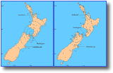 Following
an earthquake, Mercalli intensity values can be plotted on a map and
concentric lines connecting values of equivalent intensity (isoseismal
lines) drawn. This visually presents the extent and distribution
of the effects of an earthquake. The resulting isoseismal maps
often have elongate patterns, oriented along the strike of the
fault because the fault may have been displaced long a substantial
portion of its total length (Rahn 1986). Isoseismal maps can also
be plotted for historic earthquakes (Fig. 12) , based on eye-witness
accounts and reports, from which estimates of magnitudes and epicentres
for these events can be made (Aitken and Lowry 1995). For shallow
focus earthquakes there is a rough relationship between magnitude
and the maximum intensity (Imax), based on isoseismal plots
as follows (Equation 1): Following
an earthquake, Mercalli intensity values can be plotted on a map and
concentric lines connecting values of equivalent intensity (isoseismal
lines) drawn. This visually presents the extent and distribution
of the effects of an earthquake. The resulting isoseismal maps
often have elongate patterns, oriented along the strike of the
fault because the fault may have been displaced long a substantial
portion of its total length (Rahn 1986). Isoseismal maps can also
be plotted for historic earthquakes (Fig. 12) , based on eye-witness
accounts and reports, from which estimates of magnitudes and epicentres
for these events can be made (Aitken and Lowry 1995). For shallow
focus earthquakes there is a rough relationship between magnitude
and the maximum intensity (Imax), based on isoseismal plots
as follows (Equation 1): Imax = 2 Mb - 4.6 Table 1. The Mercalli Scale of earthquake intensity (after Bryant 1991).
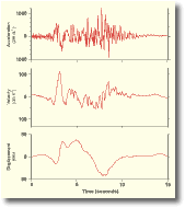
Acceleration Figure 13.
|
|||||||||||||||||||||||||||||||||||||||||||||||||||||||||||||||||||||||||
|
|||||||||||||||||||||||||||||||||||||||||||||||||||||||||||||||||||||||||