Distribution
and Causes
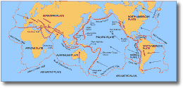
Figure
6.
Earthquakes are not randomly distributed around the earth, rather
they are located in distinct zones which can be related to the margins
of tectonic plates on the Earths surface. Figure 6 shows
the distribution of areas of most frequent earthquake activity.
The active plate boundaries are superimposed on this map. There
is a striking correspondence between the occurrence of earthquake
activity and the boundaries of plates (Bryant 1991).
Earthquakes predominantly occur in two places (1) near convergent
plate margins and (2) at divergent plate margins.
(1) Convergent plate margins:
(a) Where two sections of the Earths lithosphere are colliding,
with an oceanic plate beneath the other descending, subduction
zones occur. The ocean (whether it be oceanic or continental)
trenches and andesite volcanoes are located above subduction zones.
(b) Where two or more plates of continental composition collide,
neither can be subducted and mountain-building zones occur.
The Himalayas and European Alps occur along mountain-building, convergent
plate margins.
Subduction zones account for the majority large and deep earthquakes
(Bryant 1991, see also Fig. 6).
(2) Divergent plate margins:
Divergent plate margins occur where the lithosphere is separating,
or pulling apart and new ocean floor is formed, e.g. the mid-Atlantic
Ridge. Active volcanism at these margins is generally submarine,
but may occur subaerially, e.g. in Iceland. Most earthquakes here
are small to moderate in size and are generally shallow.
Movement of molten rock or magma in volcanoes is also generally
associated with earthquakes. However, about 75 % of all earthquake
energy is released as shallow tectonic earthquakes and along plate
boundaries. Further, very little earthquake activity is generated
beyond about 700 km below the Earths surface. A small but significant
number of earthquake events also occur which are unassociated with
either volcanism or plate boundaries, e.g. on the Australian continent,
which has generally been considered to be aseismic (Bryant
1991).
Causes
Sea floor spreading and plate tectonics
The crust along the ridges in the centre of oceans spreads because
of diverging convection cells in the mantle (The theory of plate
tectonics). The cells rise towards the earths crust, spread out
at the surface and create a rift called a mid-ocean ridge. This
rift is filled with molten material from the mantle which may form
submarine lava flows. Material spreads apart from this zone to form
new oceanic lithospheric plates.
The new oceanic plate comprises two layers. The upper part is cold,
brittle rock made up of lavas and dykes formed at the ridge, together
with minor amounts of ocean sediments. This is termed 'crust'. Welded
on beneath it is a layer of cooled, dense and brittle upper mantle.
Termed the 'lithospheric mantle'. Together the two layers are termed
the lithosphere and form an oceanic plate.
(Continental plates are similarly made up of two layers but the
crustal layer comprises low density rocks such as granites, sediments
and metamorphic rocks rather than basalt.)
Figure 7.
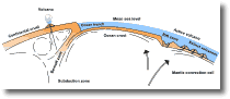 However,
where plate boundaries collide, one plate may be pushed beneath
the other, forming an oceanic trench (Fig. 7). The top of
the descending plate, or slab, is recognised from seismic activity
as the Benioff Zone, a zone of intense earthquake activity. However,
where plate boundaries collide, one plate may be pushed beneath
the other, forming an oceanic trench (Fig. 7). The top of
the descending plate, or slab, is recognised from seismic activity
as the Benioff Zone, a zone of intense earthquake activity.
The Benioff zone is a primary zone of earthquake activity because
it represents compression between two plates over a wide area. As
the depth of the Benioff zone increases, so too do the earthquake
foci. Hence deep earthquakes (70-700 km depth) occur mainly beneath
the overriding plate or continental side of the subduction zone.
Plate collisions may also involve continental crusts colliding,
causing uplift and delamination, e.g. the Indian plate overriding
the Eurasian plate. Plates may also slide past each other, e.g.
the Pacific and North American plates along the San Andreas faultline,
or the Australian and Pacific Plates along the Alpine Fault in New
Zealand.
As plates move relative to one another the Earths crust is being
compressed or stretched and pulled in different directions, building
up strain within the crust. When this strain becomes too great the
crustal rock fractures to form faults. The fracturing may happen
gradually (fault creep), or as a sudden event (or series
of sudden events or episodes) creating tectonic earthquakes.
Figure 8.
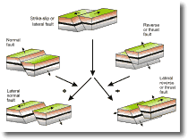 Different
types of faulting occur depending on the characteristics of the
fault. Figure 8 depicts the main types of faulting associated with
earthquake activity. The angle of dip of the fault has a strong
influence on surface shaking; earthquakes on steeply dipping faults
have a smaller zone of influence than gently dipping faults. For
example damage from moderate earthquakes along the steeply dipping
San Andreas fault rapidly diminishes within 20 km of the fault line.
In contrast the 1964 Alaska earthquake, focussed on the shallow
dipping Danali fault system in a seismically active zone corresponding
to low angle subduction of the Pacific Plate (Aleutian trench, see
Fig. 6), was widespread, with
uplift and subsidence occurring in a belt hundreds of kilometres
wide (Bryant 1986, p. 200-201). Different
types of faulting occur depending on the characteristics of the
fault. Figure 8 depicts the main types of faulting associated with
earthquake activity. The angle of dip of the fault has a strong
influence on surface shaking; earthquakes on steeply dipping faults
have a smaller zone of influence than gently dipping faults. For
example damage from moderate earthquakes along the steeply dipping
San Andreas fault rapidly diminishes within 20 km of the fault line.
In contrast the 1964 Alaska earthquake, focussed on the shallow
dipping Danali fault system in a seismically active zone corresponding
to low angle subduction of the Pacific Plate (Aleutian trench, see
Fig. 6), was widespread, with
uplift and subsidence occurring in a belt hundreds of kilometres
wide (Bryant 1986, p. 200-201).
Dilatancy
Crustal rocks at depths > 5 km are subject to a great thickness
of overburden. The pressure due to the weight of overlying rock
is usually less than the strength of unfractured rock. Sudden failure
of crustal rocks is unlikely and the rock will deform plastically
as the forces required to overcome this pressure difference generally
are not applied fast enough to cause failure. If the rocks are too
rigid to deform in this manner, however, cracks will open up in
the rocks, causing the rock to expand in volume, and this is referred
to as dilation. Water entering these cracks provides lubrication
and the release of any remaining stresses (Bryant 1991. P. 180-181).
This phenomenon of dilatancy has been used by Russian scientists
in the past to try to predict earthquakes. Rapid build up of stress
prior to rupture was thought to cause dilation which lowered ground
water in wells as the water entered the cracks. Thus by measuring
well levels the Russians sought to predict an earthquake. Accurate
timing of an earthquake event, however, remained elusive.
Human-made earthquakes
The only way that humans can "make" earthquakes is through
nuclear explosions. However, situations arise where humans have
changed conditions at places where tectonic stresses already exist,
and by doing so triggered movement along a fault. Good examples
of this phenomenon are (1) reservoir construction and (2) ground
water recharge and water/fluid injection. Both of these act to increase
pore fluid pressures which allows rupturing and movement along the
fault by lowering the strength of the rock (Rahn 1986). Considering
that injection of fluid into the crust triggers earthquakes, it
seems likely that removing liquid should have the opposite effect.
However, earthquakes also occur in oil fields and gas fields where
fluids are withdrawn. Here contraction of the underground reservoir
rock causes these earthquakes. Vertical contraction simply causes
the ground surface to slump. Horizontal contraction creates stresses
in the surrounding rocks, which are pulled into the reservoir, deforming
and fracturing to trigger earthquakes.
An example of a human-made earthquake triggered by reservoir construction
occurred on 10 December, 1977 when a seismic shock of magnitude
6.4 happened near the Koyna Dam, India. This earthquake killed 177
people and caused extensive damage. The area had previously been
aseismic, but since the dam began filling in 1962 there had been
a noticeable increase in seismic activity.
Visual evidence of faults and earthquakes in the
landscape
Figure 9.
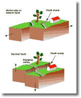 The
surface expression of a fault on which there has been a recent earthquake
is termed a fault break. In general fault breaks do not occur
for earthquakes below about magnitude 6. Fault scarps are
associated with displacements along most fault types. In normal
and thrust faulting, scarps result from the opposite displacement
of ground on either side of the fault (Fig. 9). The upthrust
block is termed the hanging wall and the down thrust block
is termed the footwall. Strike-slip faulting results in the
creation of scarps where the fault crosses uneven topography, e.g.
a valley. Stream channels are displaced sideways by strike-slip
faulting, creating a distinctive s-bend channel morphology which
is common across all the stream channels affected by the fault.
Hanging valleys may be created by normal and thrust faulting
(Fig. 9). The
surface expression of a fault on which there has been a recent earthquake
is termed a fault break. In general fault breaks do not occur
for earthquakes below about magnitude 6. Fault scarps are
associated with displacements along most fault types. In normal
and thrust faulting, scarps result from the opposite displacement
of ground on either side of the fault (Fig. 9). The upthrust
block is termed the hanging wall and the down thrust block
is termed the footwall. Strike-slip faulting results in the
creation of scarps where the fault crosses uneven topography, e.g.
a valley. Stream channels are displaced sideways by strike-slip
faulting, creating a distinctive s-bend channel morphology which
is common across all the stream channels affected by the fault.
Hanging valleys may be created by normal and thrust faulting
(Fig. 9).
Neotectonics
Neotectonics is the study of recent earth movements. Embracing
many disciplines, including geology, geophysics, geodesy, history
and archaeology, it aims to achieve an understanding of the most
recent movements to have modified the Earths crust, and extend
the record of past earthquakes back in time before historic records
began.
In general most plate interiors are subject to compressional stress,
although there may be some local tension. Compression and extension
directions can be determined from earthquake seismograms.
Seismogram records can also be used to determine the orientation
of a fault, the sense of slip of a fault, and the direction of the
compression and extension causing the faulting (Hancock 1988).
Most earthquakes that cause strong ground-shaking and rupture occur
on faults in the zones separating plates (e.g. the San Andreas
fault on the margin between the North American and Pacific plates,
see Fig. 6). A few occur on
faults within plates (e.g. the continent of Australia, the New Madrid
area in the eastern USA). These earthquakes occur infrequently,
yet when they are triggered may be very destructive because they
are unexpected. Recognizing fault scarps allows us to trace active
faults, and by studying the landscape and deposits that have been
affected the ages of faulting events can be determined. Active
faults are defined as faults which are likely to be active in
a time span of concern to society.
Figure 10.
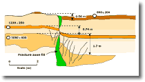 Neotectonic
investigations are based on geological or geomorphological investigations
of the surface representation of past earthquakes, e.g. displaced
rocks, landforms or human occupation sites. An ideal site is one
where radiometric, palaeotological and/or anthropological dates
are available (e.g. from preserved pieces of wood, shells or artifacts).
For each different offset on the fault, a corresponding earthquake
may be inferred (Fig. 10). Neotectonic
investigations are based on geological or geomorphological investigations
of the surface representation of past earthquakes, e.g. displaced
rocks, landforms or human occupation sites. An ideal site is one
where radiometric, palaeotological and/or anthropological dates
are available (e.g. from preserved pieces of wood, shells or artifacts).
For each different offset on the fault, a corresponding earthquake
may be inferred (Fig. 10).
|