|
|
||||||
Large Landslides
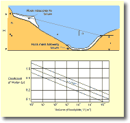
Spectacular examples of the debris avalanches occurred at Nevados Huascaran, Peru, in 1962 and 1970 when earthquakes destabilised a large section of the mountain. The 1962 debris avalanche (which started as an ice fall high on the slopes of the mountain) fell nearly 4,000 m and took only 5 minutes to travel 14 km to the village of Ranrahiraca which it buried along with 3,500 inhabitants. This debris avalanche gave an indication that the slopes of Huascaran were very unstable. In 1970 another debris avalanche swept down off the mountain, this one starting at about the same place as the previous event, but was 4 times as large. The debris avalanche traversed a ridge a 230 m high ridge and within 3 minutes engulfed the town of Yungay 14 km downslope killing an estimated 20,000 people. The debris avalanche became airborne as it flowed over a sharp break in slope. It was able to transport huge boulders up to 65 tonnes in weight and when it became airborne thousands of boulders were flung over a wide area and up to 4 km from the launch point devastating the communities below. This was a truly catastrophic debris avalanche (Costa and Baker, 1984, p. 271-270). Analysis of these large landslides involves establishing parameters such as total vertical fall height (H), the slide mass (m), its velocity of movement (V), its maximum runup (r), net vertical fall (h = H-r) and the average slope over which the slide moves (angle a) (Figure 5). The velocity for landslides can be estimated based on the height to which they runup over obstacles or valley-sides:
where g is acceleration due to gravity (9.8 ms-1). This method does not take into account frictional losses as the landslide flows uphill against gravity so is only a minimum value. Frictional loss is difficult to estimate, but it is possible to determine a coefficient of friction. In Figure 5 the average coefficient of friction, m, for the landslide is:
The coefficient of friction has been calculated for a number of large landslides, and plotted against their total volume (Fig. 5). There is a fairly good relationship between the two factors, and this means that if the volume of unstable material is estimated then m can be determined. Substituting m and h into the equation above allows the horizontal distance that the landslide might travel to be calculated.
|
||||||
|
||||||