Case
Studies: Landslides in New Zealand
The economic cost of landslides in New Zealand is difficult to
analyse as in major storms landslides generally occur in association
with flooding. It is the flooding which has the immediate economic
impact with sedimentation on the river flats. Whether the sedimentation
results from landslide erosion or fluvial erosion cannot be distinguished
accurately enough to allow analysis to be carried out. In 1984 John
Hawley, then Scientist in Charge of the Soil Conservation Centre,
estimated the average cost of landslides in the pastoral hill country
to be in excess of $20 million per year.
The immediate costs can be large, i.e. following Cyclone Bola,
a three-day cyclone in March 1988 during which up to 900 mm of rain
fell devastating large tracts of the Gisborne-East Coast and North
Hawkes Bay regions (Table 2), the government allocated $50 million
to compensate farmers for losses in production. The damage to land,
housing, communications and services is estimated to have cost more
than $100 million.
Landslides in urban environments are common in cut and fill situations
with houses and roads being undercut or inundated with debris. The
most significant urban landslide in New Zealand's history occurred
in 1979 when the Abbotsford block slide, covering 18 ha, caused
the destruction or removal of 14 houses in the Green Island Borough
of Dunedin (Table 2). The main movement comprised a 50-m slide at
a rate of about one metre per minute and occurred within an hour,
sliding along a bedding plane failure surface dipping at 7 degrees.
While claims under the Earthquake and War damage Act amounted to
nearly $3 million, it is likely that the total cost of this one
landslide to New Zealand was $10 - 15 million.
Table 2. Significant landslide events in New Zealand
| Location |
Date |
Cause |
| Murchison and Upper Matiri Valley
|
1929 |
Earthquake-induced landsliding,
damming of rivers by landslides |
| Devils Elbow, Hawkes Bay |
1938 |
Debris slides and avalanches
triggered by heavy Rainfall |
| Inangahua, South Island |
1968 |
Landslides, damming of rivers
by landslides |
| Abbotsford, Dunedin |
1979 |
Block slide |
| Gisborne, East Coast & northern
Hawkes Bay |
1988 |
Cyclone-triggered landslides
(Cyclone Bola) |
| Mount Cook |
1992 |
Debris avalanche |
Banks Peninsula and Port Hills (Bell and Trangmar
1987)
In this case study we examine the association between soil type
and land instability in the fine-grained loessial and volcanic soils
of the Port Hills and Banks Peninsula, Christchurch. Eroded volcanic
craters form Banks Peninsula and these are mantled by loess and
colluvium. Erosion of these material has been along term problem
for land users in the region, especially in the Port hills, where
urban development is encroaching on lower slopes. Erosion processes
are related to the type of subsurface material or regolith.
Soil/regolith types and land instability
Five principal soil/regolith types are recognised:
1. In situ loess - during past glaciations of
the Southern Alps fine silt-sized material was produced by the grinding
action of glacial ice. This was transported by the rivers draining
the glaciers out onto the wide river flood plains where it was deposited.
When it dried it was blown from the floodplain onto the surrounding
hillslopes. Loess occurs mainly in the summits and shoulders of
the interfluves and rims of the old volcano. It also occurs in footslope
positions where it is buried by colluvium.
Two types of loess occur:
1. Birdlings Flat loess occurs on the lower interfluves. It is
generally highly dispersive and slakes readily when wetted. It
has low cohesion between particles and a low capacity for moisture
retention.
2. Barrys Bay loess occurs at the valley heads and summits of
the interfluves. Barrys Bay loess is finer grained than Birdlings
Flat loess, has greater cohesion and is not as dispersive.
2. Loess-colluvium - this includes all loessial
materials that have been transported downslope since the material
was first deposited. It is formed of fine grained sand and silt.
It also includes small amounts of volcanic rock material derived
from upslope outcrops. Loess-colluvium occurs on shoulders, backslopes,
footslopes and toeslopes and will have characteristics corresponding
to the loess from which it is derived. Loess-colluvium may overlie
basement volcanic rock, loess or older colluvium. The age, distribution
and composition of the loess-colluvium varies, creating layering
within the loess-colluvium. Contacts between these layers often
provide failure surfaces for landslides, or discontinuities above
which tunnel-erosion can occur.
3. Volcanic colluvium - this material comprises
weakly to moderately weathered volcanic rocks fragments which are
supported and surrounded by highly weathered silty clay or clay
loam. It occurs on moderately steep mid-backslopes immediately below
outcrops of volcanic rocks. The surface of the volcanic bedrock
underlying the volcanic colluvium is usually slightly weathered,
but is highly weathered in a few localities. With distance from
the outcrops volcanic colluvium grades to mixed colluvium.
4. Mixed loess- and volcanic-colluvium - mixed
colluvium consists of loess-colluvium mixed with weathering products
derived from the volcanic rocks that outcrop upslope. Mixed colluvium
occurs on backslopes and upper footslopes below outcrops of volcanic
rocks. These outcrops are often associated with seepage zones. Where
mixed colluvium overlies in situ loess or colluvium the upper layer
of the underlying material is firm and in winter a perched water
develops above this contact. The surface of zones of mixed colluvium
are often hummocky showing evidence of past slope instability. Mixed
colluvium is the regolith type most prone to landslides.
5. Residual regoliths - residual regolith is
formed from the weathering of volcanic bedrock at the summits and
shoulders of ridges where covering material has been removed. The
regolith is thin, and volcanic outcrops commonly protrude through
the material. Runoff from the erosion surface is usually high during
rainfall causing landslides and erosion downslope.
Six forms of erosion are associated with these regolith
types: 1. Rock and debris falls
2. Soil creep
3. Slide-avalanche-flow mass movements
4. Sheet and rill erosion
5. Tunnel-gully erosion
6. Wind erosion
Slope failures in natural ground generally occur within the
colluvial and mixed-colluvial deposits and slope stability within
these deposits is controlled by their distribution and geotechnical
properties. The most common triggering mechanisms are a function of
intensity, magnitude and duration or rainstorms, and the antecedent
moisture conditions within the regolith.
Of principal concern to this study guide are the first three erosion
types. However, the latter three, sheet and rill erosion, tunnel gully
erosion and wind erosion are all processes which can lead to slope
instability and subsequent slope failure.
Table 9 identifies the main factors which influence
erosion and slope instability for each regolith type. Each of the
process identified poses problems for urban development in the Port
Hills and slide-avalanche-flow mass movements and tunnel-gully erosion
causing the greatest concern. For example slide-avalanche-flow mass
movements may cause damage to surface structures including houses,
fences and roads, or underground services including power cables,
sewer and water pipes. Rockfalls may damage houses and fences, debris
falls from road cuttings etc. may block drains and cause minor structural
damage. Soil creep will crack foundations and pathways, disrupt underground
services and cause tilting of fences, service poles and trees.
Table
9. Hillslope instabilities related to surficial material type
and characteristics (from Bell and Trangmar 1987).
| Erosion type |
Regolith type
|
Regolith properties
influencing erosion |
Other factors |
| TUNNEL-GULLY |
Loess, loess-colluvium |
1. Low intergranular cohesion.
2. Rapid slaking and dispersion when wetted.
3. Low permeability layers (fragipan) above which water moves
downslope forming tunnels.
4. Susceptibility to scouring by flowing water.
5. Cracking in summer due to shrinkage. |
1. Dry aspects.
2. Seasonal wetting and drying.
3. Discontinuous vegetation cover in summer.
4. Slopes 3-35o.
5. Inefficient storm water disposal. |
MASS MOVEMENTS
(SLIDE-AVALANCHE-FLOW) |
Loess-colluvium,
mixed alluvium |
1. Impeded internal drainage.
2. Saturation of material above low permeability layers.
3. Heterogeneous composition causing variable strength.
4, Low shear strength when saturated.
5. Potential failure surface along fragipan, layers of colluvium,
colluvium/bedrock or colluvium/loess contact.
|
1. Strong gravitational forces on
slopes 18-35o.
2. Shady aspects or gullies.
3. Seepage zones.
4. Cut and fill excavation.
5. Inefficient stormwater disposal. |
| Volcanic alluvium |
1. Shallow regolith with low moisture
storage.
2. Potential failure surface at colluvium/bedrock contact.
3. As in 3 for loess-colluvium |
1. Slope > 28o.
2. Seepage zones |
| SOIL CREEP |
Loess, loess-colluvium, mixed colluvium
|
1. Impeded internal drainage
2. Plastic behaviour of saturated loess under gravitational
stresses.
3. Potential failure surfaces along fragipan, layers of colluvium,
colluvium/bedrock, or colluvium/loess contact.
|
1. Seasonal and diurnal
wetting and drying of soil aggregates.
2. Seasonal and diurnal temperature changes.
3. Stock trampling.
4. Cut and fill excavation.
5. Strong gravitational forces on slopes 7-38o.
6. Gullies with slow site drainage. |
| Volcanic |
1. Potential failure surface along
colluvium/bedrock contact. |
| SHEET AND RILL EROSION |
All regolith types |
1. Friable, weakly structured topsoils.
2. Desiccation of topsoils in summer.
3. Dispersive soils where loess content high.
4. Thin, slowly permeable crust formed on soil surface by sheet
wash reduces infiltration and increases runoff. |
1. Summer moisture deficiency causes
topsoil desiccation.
2. Discontinuous vegetation cover.
3. Rapid runoff following heavy rainfall, especially from shallow
regoliths.
4. Increases in runoff velocity a slope angle increases (slopes
> 7o).
5. Severe sheet erosion leads to rilling. |
Problems have occurred in the Port Hills area when:
1. Fill is placed on a loessial slope without prior benching,
causing slide movements above the fill-buried soil contact.
2. Vertical barriers greater than 1 m high are used to prevent
shallow gully erosion and surface erosion but then trigger deeper
tunnel-gully erosion below the fragipan.
3. Underground service trenches are installed on sloping ground
and initiate subsurface erosion as a result of seepage.
Prevention and remedial measures
Detailed engineering soil maps are available at 1:10,000 scale.
However, detailed site investigations at smaller scale are required
to identify and characterise the regolith materials. Once this has
been done different approaches to minimising the impact of development
can be used. In the case of the sensitive materials on the Port
Hills these may include:
1. Minimising excavation and ground disturbance, e.g. pole frame
house design.
2. Stabilising dispersive loess soils through chemical treatment,
particularly using hydrated lime.
3. Backfilling erosion cavities and service trenches.
Clyde Dam (Electricorp Production 1989)
Figure 10.
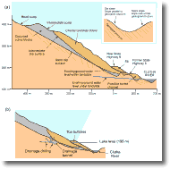 In
this case study we examine the problems associated with development
of the Clyde Dam hydro-scheme on the Clutha River and landslides
within the Cromwell Gorge. Over a period of hundreds of thousands
of years the Clutha River has carved out its channel through the
Dunstan and Cairnmuir Ranges. During this time the rocks of the
ranges have been folded and foliated, creating seams of clay and
joints within the rock. These are potential failure planes and landslides
are associated with the processes that have formed the Cromwell
Gorge. The thin clay seams form parallel to the layering of the
rock where sliding has occurred. Where the layering dips subparallel
to the hillslope (dip slope) and towards the river large rock masses
can slip downslope (Figure 10). This condition occurs at the Clyde
Dam site and upstream in the Cromwell gorge. Conditions are generally
stable when the rock layering dips sub-perpendicular to the hillslope
(scarp slope). In
this case study we examine the problems associated with development
of the Clyde Dam hydro-scheme on the Clutha River and landslides
within the Cromwell Gorge. Over a period of hundreds of thousands
of years the Clutha River has carved out its channel through the
Dunstan and Cairnmuir Ranges. During this time the rocks of the
ranges have been folded and foliated, creating seams of clay and
joints within the rock. These are potential failure planes and landslides
are associated with the processes that have formed the Cromwell
Gorge. The thin clay seams form parallel to the layering of the
rock where sliding has occurred. Where the layering dips subparallel
to the hillslope (dip slope) and towards the river large rock masses
can slip downslope (Figure 10). This condition occurs at the Clyde
Dam site and upstream in the Cromwell gorge. Conditions are generally
stable when the rock layering dips sub-perpendicular to the hillslope
(scarp slope).
Cromwell Gorge landslides and the Clyde Dam
The landslides are at Clyde Dam and in Cromwell Gorge are slow
creeping features, moving at an estimated < 300 mm per year and
terrace surface s 15-18,00 years old at the foot of the landslides
are not disturbed which is further evidence for their slow movement.
However, a major concern is how the filing of the Clyde Dam hydro
lake will affect the rate of movement of these landslides. It is
imperative to avoid a similar situation to that which arose at Vaiont,
Italy (see Table 1).
The effects that lake filling may have on the landslide are:
1. Wetting of clay seams along which sliding has occurred - this
will lead to a decrease in strength and hence stability
2. Wetting of landslide toe materials will decrease the effective
weight of the rock and reduce frictional resistance in this part
of the landslide and decreasing stability. The affect is greater
where the landslide toe is currently dry and least where it is already
wet.
3. The rising water level will affect groundwater systems within
the landslide and may lead to rises in water pressure thus reducing
cohesion and leading to landslide instability.
Prevention and remedial measures
Geological maps are available at regional scale (1:50,000). Detailed
mapping and ground studies of the distribution and nature of landslides
and landslide scars identified the processes that lead to slope
instability. Other approaches adopted include:
1. Monitoring - all the major landslides have surface survey
points and inclinometer holes for measuring surface and subsurface
ground and regolith movements, respectively. Observation wells measure
variations in ground water levels. Monitoring of the dam and reservoir
following filling will continue following filling
2. Toe buttressing and gravity drainage stabilisation (Fig.
10).
|
