2 Proceedings of The Hong Kong Engineers Managing Slope Safety in a High Density City
|
|||||||||||||||||||||||||||||||||||||||||||||||||||||||||||||||||||||||||||||||||
| Slope Safety System components | contribution by each component | ||
| to reduce landslip risk | to address public attitudes | ||
| hazard | vulnerability | ||
| policing | |||
| • | |||
| • | • | ||
| • | |||
| • | |||
| safety standards and research | • | • | |
| works projects | |||
| • | |||
| • | |||
| education and information | |||
| • | • | ||
| • | • | ||
| • | • | • | |
| • | • | • | |
services |
• | • | • |
| • | • | ||
Evaluation of the Slope Safety System to date
To evaluate the Slope Safety System to date it is necessary to begin by examining evidence of change in global landslip risk (i.e. landslip risk for the entire territory) in the last 20 years and then to go on to examine, if possible, the efficiency and effectiveness of the component parts of the system.
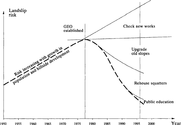
If landslip risk has been reduced by the Slope Safety System, the trend depicted in Figure 3 ought to be apparent. This trend is based on the premise that risk grew broadly in proportion to population until arrested by the intervention of the Slope Safety System. It is postulated that without the Slope Safety System, landslip risk would have continued to increase with continuing growth in population, the encroachment of development onto steeper terrain, the increase in the number of man-made features and their deterioration due to lack of maintenance.
Figure 3. Hypothetical risk trend.
To measure change in risk with time, quantified risk analyses (QRAs)
must be carried out for different times and this work has not yet
been done. Evaluation will therefore have to rely for the present
on indication of risk rather than calculation of risk by QRA.
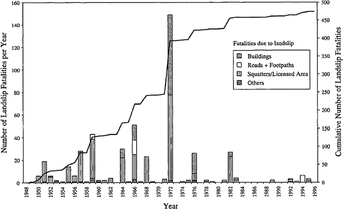
A reducing trend with time in the amount of harm and damage occurring annually due to landslips, when normalized for rainfall, would be a prima facie indication of a reduction in risk. Trends in data can be revealed by plotting rolling averages (i.e. moving averages) and this technique is adopted here, using a 15- year datum period after trying several other periods. The plots in Figures 4 and 5 utilize landslip fatality data for the whole territory and rainfall data from the Royal Observatory Tsim Sha Tsui gauge. The past 15-year rolling averages of annual number of landslip fatalities are given in Figure 4. In an attempt to discern trends in rainfall the 15-year rolling averages of the annual number of heavy rainfall events, defined as 24-hour rainfall greater than 175 mm (Figure 5), and the 15-year rolling average annual rainfall are also plotted (Figure 5). The former criterion is chosen because the occurrence of 175 mm of rain in 24 hours at Tsim Sha Tsui is the main Landslip Warning criterion and the data is readily available.
Figure 4. Past 15-year rolling average of annual number of landslip fatalities.

Figure 5. Rainfall trends.
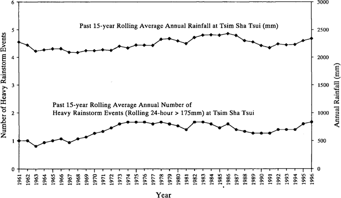
The trend in 15-year rolling annual fatalities resembles that shown
in Figure 3 but there is no
corresponding reduction in annual rainfall or the number of heavy
rainfall events. This finding may be interpreted as indicating a
reduction in risk. Another indication of reduction in risk would
be any reducing trend in territorial landslip fatality rate with
increasing territorial population. The data are plotted in Figure
6. The trends evident in Figures 4 and 6 provide prima facie evidence
of significant risk reduction since the end of the 1970s.
Figure 6. Trend of fatalities with population growth.
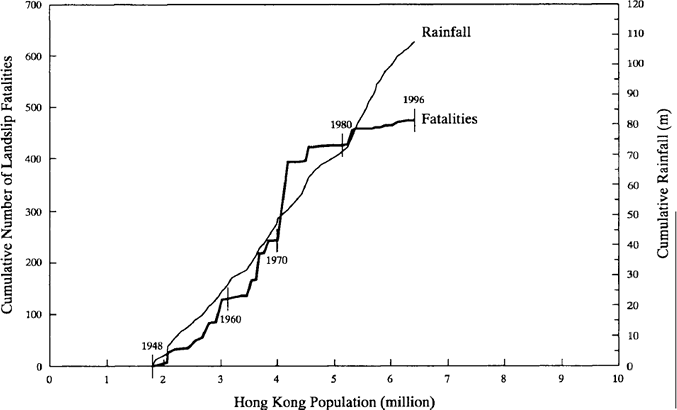
In evaluating the efficiency of the Slope Safety System as a whole
in terms of outcome, the
fundamental question is 'is Hong Kong getting value for money in
terms of cost/benefit?'
Projecting forward the fatality rate trend prior to the 1980s it
appears that an annual fatality rate (15-year rolling average) of
the order of twenty-five fatalities per year might have been reached
by 1996. In fact the actual annual fatality rate in 1996 (15-year
rolling average) was of the order of three fatalities per year.
Taking these figures, attributing the reduction to the Slope Safety
System, making assumptions about the 19-year cost of the Slope Safety
System and charging its entire cost to saving life only, it is estimated
that up to the end of 1996 each life saved has cost about $20 million.
This price would probably be regarded as cost-effective by the stakeholders.
Judged on the UK Health and Safety Executive's tolerability rationale
(commonly known as the ALARP or 'as low as reasonably practical'
rationale) $20 million is higher than but not grossly disproportionate
to the values of statistical life assumed in risk assessments for
technological hazards in Hong Kong current practice. Therefore,
purely on the ALARP rationale, the need is indicated for continuing
investment in landslip risk reduction in Hong Kong.
Conclusions
The trends indicated in Figures 4 and 6 provide prima facie evidence
of significant risk reduction in the past twenty years which may
be attributed to the Slope Safety System introduced progressively
since the late 1970s. Crude calculations indicate that the risk
reduction effort has been cost-effective and should be continued.
Acknowledgements
The paper is published with the permission of the Director of Civil
Engineering of the Hong Kong Government.
References
1. Chan, Y.C., Pun, W.K., Wong, H.N., Li, A.C.O. & Yeo, K.C. (1996) Investigation of some major slope failures between 1992 and 1995. Geotechnical Engineering Office, Hong Kong, 97 p. (GEO Report No. 52).
2. Geotechnical Engineering Office (1993a) Report on the Rainstorm of May 1982, by M.C. Tang (1993), 129 p. plus 1 drg. (Reprinted, 1995).
3. Geotechnical Engineering Office (1993b) Report on the Rainstorm of August 1982, by R.R. Hudson (1993), 93 p. plus 1 drg. (Reprinted, 1995).
4. Geotechnical Engineering Office (1994) Report on the Kwun Lung Lau Landslide of 23 July 1994, Volume 2: Findings of the Landslide Investigation. Geotechnical Engineering Office, Hong Kong, 379 p. (Chinese version, 358 p).
5. Geotechnical Engineering Office (1996a) Report on the Fei Tsui Road Landslide of 13 August 1995, Volume 2: Findings of the Landslide Investigation. Geotechnical Engineering Office, Hong Kong, 68 p. (Chinese version, 64 p).
6. Geotechnical Engineering Office (1996b) Report on the Shum Wan Road Landslide of 13 August 1995, Volume 2: Findings of the Landslide Investigation. Geotechnical Engineering Office, Hong Kong, 51 p. (Chinese version, 49 p).
7. Hong Kong Government (1972a) Interim Report of the Commission of Inquiry into the Rainstorm Disasters, 1972. Hong Kong Government Printer, 22 p.
8. Hong Kong Government (1972b). Final Report of the Commission of Inquiry into the Rainstorm Disasters, 1972. Hong Kong Government Printer, 94 p. (Also published in Chinese, 99 p.)
9. Hong Kong Government (1977). Report on the Slope Failures at Sau Mau Ping, August 1976. Hong Kong Government Printer, 105 p. plus 8 drgs.
10. Malone, A.W. & Ho, K.K.S. (1995). Learning from Landslip Disasters in Hong Kong. Built Environment, 21, no 2/3, 126-144.
| [1. Slope Safety Systems] | [Subsidence] |
| |
|
